
When hikers plan a trip to conquer the high peaks of northern England, their itineraries naturally skew toward the popular, crowded paths of the Lake District or the Yorkshire Three Peaks.
Yet, tucked away in Lancashire sits the Forest of Bowland, an Area of Outstanding Natural Beauty (AONB) that offers a raw, dramatic sense of wild isolation.
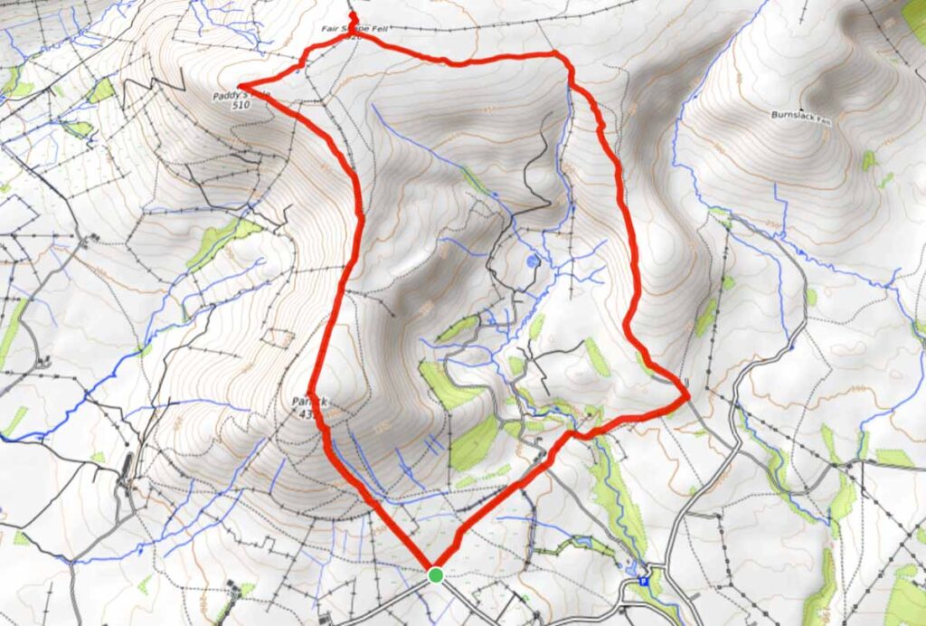
Amongst the countless ridges tracing this protected landscape, the combined horseshoe route up Parlick and Fair Snape Fell stands out as one of the finest fells walks in the county.
This route allows you to knock out two distinct peaks in a single afternoon without dedicating a full day to the trail.
Having summited these ridges multiple times, I can verify that the expansive, windswept vistas are spectacular.

Even better, the trails remain blissfully quiet compared to the neighboring national parks, allowing you to immerse your senses completely in the fresh Lancashire air.
Here is the complete route manual, trailhead logistics, and navigation data for the loop.
🥾 Fair Snape Fell & Parlick Walk Logistics
Distance:
5.8 miles (9.3 km) for the classic circular loop from Startifants Lane/Fell Gate
Time Required:
3 to 3.5 hours at a steady hiking pace.
Total Ascent:
395 metres (1,295 feet).
Terrain:
Steep grassy paths on the initial ascent up Parlick, transitioning into wide, peat-heavy ridge tracks and flagstoned paths across the upper fell plateaus. Can become exceptionally boggy and saturated during the winter months.
Trailhead & Parking:
At the Eastern end of Startifants Lane on Fell Gate, near Chipping, Lancashire (Postcode: PR3 2NZ). There is a small gravel layby with space for a few cars. If this is full, you must park responsibly.
Dog-Friendly Factor:
Fantastic for active dogs, but because the open fells are a working sheep common, dogs must be kept on a short lead on a lot of the walk to protect local livestock.
The Trailhead: Startifants Lane to Saddle End
The journey kicks off at the eastern end of Startifants Lane, a quiet lane positioned just outside the picturesque village of Chipping. At the Eastern end of the lane you will see Fell Gate on the left.
Standing at the gravel layby, you get a completely unobstructed look at the massive, green, and conical western slopes of Parlick looming directly ahead on the skyline.
Follow the rural lane up toward the historic stone buildings of Fell Foot Farm. The trail passes cleanly through a marked wooden gate, shifting instantly from tarmac to a grassy, well-worn footpath that signals the official start of the mountain climb.
The Steep Push: Conquering Parlick
Make no mistake: the opening direct route up the face of Parlick is exceptionally steep.
It is a relentless, thigh-burning grass incline that will test your baseline stamina right out of the gate.
My best guide advice here is to pace yourself deliberately. Do not try to sprint the incline; drop your heels, find a rhythmic breathing pattern, and use the steepness as a perfect excuse to frequently turn around and catch your breath.
As you gain height, the landscape opens up with astonishing speed.

Looking directly south, the nearest prominent mound you see is Beacon Fell Country Park, appearing as a tiny, tree-topped hill on the plains.
Staring past it on a clear day, your eyes can trace the vast sweep of the Fylde Coast, the urban layout of Preston, and the distant Irish Sea.
Twist your gaze eastward across the lush pastures of the Ribble Valley, and the unmistakable, elongated ridge of Longridge Fell stands out, leading your eye straight to the historic, brooding silhouette of Pendle Hill.
Reaching the summit cairn of Parlick (432m) rewards you with one of the single finest panoramic viewing platforms in Lancashire.
Even though Fair Snape Fell sits higher on the barometric register, it is Parlick that delivers the most dramatic, uninterrupted drop-off views over the lowlands.
It is a fantastic spot to drop your pack, sit on the grass, and just take in the immense scale of the county.

‘The Loveliest Mile in Lancashire’: The Wide Ridge
Leaving Parlick behind, you pivot north toward the main bulk of the Bowland massif.
The wide, sweeping ridge line that connects the summit of Parlick directly to the cairns of Fair Snape Fell is affectionately known among local walkers as ‘the loveliest mile in Lancashire.’
Walking this path is an incredible treat for the senses. The heavy physical strain of the initial climb is entirely behind you, replaced by a wide, gentle grass track that lets you wander freely across the tops.

On this section you must turn around to take the whole scene in and see why it got its nickname of the loveliest mile. Or very often I do this walk in reverse so that I can wander and look around in awe.
With my Border Collie, Malc, leading the way along the path, the sense of vast, open escapism is total. The green valleys drop away on either side, making you feel as though you are standing on the spine of the entire county.
The air is incredibly clean, the colours of the moorland shift beautifully with the seasons, and the visual line ahead frames the upcoming summit of Fair Snape Fell clearly across the high plateau.

The Summit: Peat Hags and Cloud Inversions
As you approach the high terminal point of Fair Snape Fell (511m), the underfoot terrain changes.
The solid grass tracks give way to dark, exposed peat hags, and the surrounding breeze usually transitions into a biting, fresh mountain wind that hits your face.
The true summit is marked by a traditional stone trig point alongside a massive stone windbreak shelter. Standing inside the drystone enclosure reveals an even broader perspective of the northern coast, extending across the massive tidal sands of Morecambe Bay all the way to the jagged, dark blue mountain outlines of the Lake District fells in Cumbria.
Because this fell sits so close to my home base, I find myself heading up here continuously throughout the year whenever I need a quick mental reset button.
The ease of access makes it a perfect sanctuary for a fast mountain escape.

I’ve spent numerous nights wild camping right beside the summit windbreak, watching the sun drop cleanly below the coastal horizon and waking up at dawn to witness spectacular cloud inversions—where the entire lowlands of Lancashire are completely buried beneath a thick, silent white blanket of mist, leaving only the highest peaks poking out like independent islands in a white sea.
Descending back down via the gentle eastern tracks completes a highly rewarding, classic horseshoe loop.

Driving away after the walk, down the country lanes, a quick glance back into the wing mirror reveals the unmistakable twin shapes of Parlick and Fair Snape Fell fading into the dusk light—a silent reminder of a landscape that never fails to restore the senses.
Explore More Spectacular Lancashire & Northern Walking Guides
- The Named Fell: Longridge Fell: A Walk Up Britain’s Most Southerly Named Fell
- The Historic Trail: The Tolkien Trail: A Great 6.5-Mile Circular Lancashire Walk
- The Riverside Loop: Wanders and Views at the Crook O’Lune, Caton
- The Canopy Track: A Dog Walk Through Witch Wood, Lytham


Great review Paul of one of my favourite parts of the world…
Thank you so much for this review! Thanks to you we’ve discovered such an amazing place! our new favourite 🙂
hi! a wonderful walk and area that is indeed. thanks
Tried this walk over the Weekend. Lived up to your hype. Keep up the good work.
Hi Shane! Thanks so much. Glad you enjoyed