
In the world of British hill-bagging, there is a common misconception that a summit has to be high, rugged, and intensely grueling to offer a world-class panoramic payoff.
Yet, tucked away on the border of Cumbria and Lancashire within the Arnside & Silverdale National Landscape, sits a low limestone hill that completely upends that theory: Arnside Knott.
Rising to a modest height of just 159 meters (522 feet), the Knott holds a distinct piece of geographical trivia—it is officially England’s lowest Marilyn (a hill with a relative prominence of at least 150 meters).
What makes an adventure here so spectacular is the sheer variety of landscapes stitched together onto one short peninsula.

This isn’t just a standard walk up a grassy hill; it is a journey that evolves from shifting tidal sandflats and craggy coastal cliffs into ancient mixed woodlands, exposed limestone pavements, and lush, vibrant greenery that feels entirely distinct from the stark, rocky fells of the high Lake District.
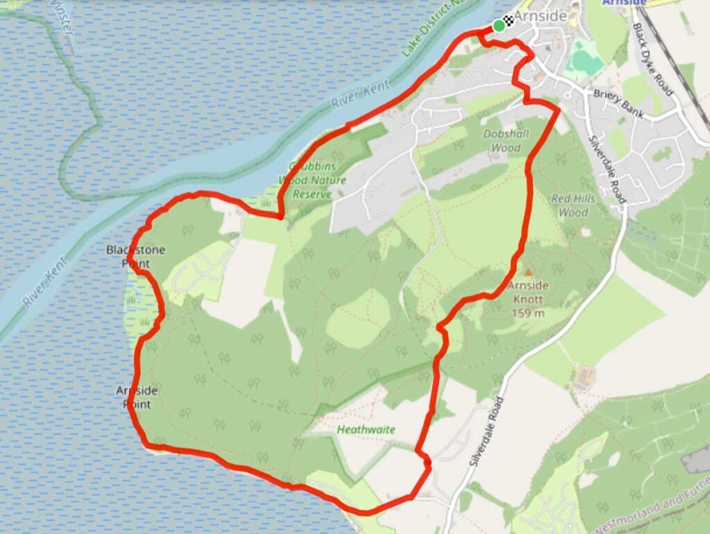
Because I come back to this beautiful corner of Britain regularly, I have developed a preferred 5-mile circular route that unlocks the absolute best of the area.
Instead of shortcutting the experience by driving up to the high car park, this route hits the ground at sea level, letting you earn the panoramic mountain views by tracking the dramatic coastline first.
🗺️ Arnside Shoreline & Summit Blueprint
Geographic Location:
Straddling the southern coastal border of Cumbria and Lancashire, framed by the Kent Estuary and Morecambe Bay.
The Navigation Hub:
The adventure begins and ends on the shoreline promenade of Arnside village. Use Postcode: LA5 0HA for your satellite navigation.
Trail Distance & Duration:
A comprehensive 5-mile (8 km) multi-terrain circular circuit. Allow a minimum of 2.5 to 3 hours of moving time to fully enjoy the coastal sections and the summit plateau.
Terrain Index:
Highly varied. Expect level seaside pavement, tidal sandflats, muddy woodland tracks, and short, steady gravel climbs over limestone bedrock.
Dog-Friendly Policy:
Exceptional variety for four-legged hikers. Dogs are completely in their element on the open sands, but they must be kept on a fixed lead through the woodlands and summit fields due to active conservation grazing by rare-breed cattle and sheep.
Parking Strategy:
Free parking is available along the main Arnside Promenade and the approach roads, provided you arrive early. If you roll into the village too late on a sunny weekend, you will find yourself restricted to the heavily monitored one-hour-only slots on the front, which simply won’t do for a full walk.
The Shoreline Start & The Fast Tides of Morecambe Bay
Setting out from the promenade early in the morning—before the main crowds descend on the village shops and cafes—is the absolute best way to catch the coast at its most peaceful.
Heading southwards from the front, the way is beautifully simple: you drop right down onto the shoreline path, tracking below the limestone cliffs with the vast expanse of the bay opening up on your right.
On a clear, low-tide morning, the views out over the estuary are surreal.
The coastal town of Grange-over-Sands sits directly across the water, appearing so close through the salty air that you feel like you could reach out and touch it, or simply stroll across the sand to its piers.
Malc had a blast! he loves water and loves to run and run in open spaces. he was in his element.

The Morecambe Bay Warning: Do not be tempted to venture out into the middle of the channel. Morecambe Bay is an incredibly beautiful but notoriously hostile environment, famous for its treacherous quicksands and an incoming tide that sweeps in faster than a person can run. Always check the local tidal charts before setting foot on the sand, keep your track closely hugged to the line of the cliffs, and if the tide is high, bypass the beach entirely by utilizing the beautiful clifftop trails running through the trees of Arnside Park.

Far Arnside & The Silhouette of the Tower
After a couple of miles of coastal tracking, the beach trail leads you seamlessly toward the peaceful caravan and chalet park at Far Arnside. This is where your route cuts inland, leaving the sea breeze behind to guide you through the quiet lanes of the hamlet before transitioning onto the public footpaths pointing back toward the Knott.
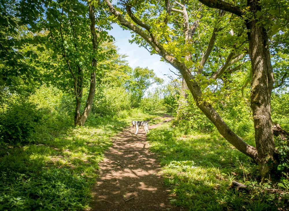
As you begin your steady, gentle climb away from the coast, the entire character of the landscape shifts. Unlike the bare, wind-scoured ridges of northern England, the terrain here is remarkably lush, dense, and green.

As you look back over your shoulder across the canopy of Arnside Park, a striking piece of local heritage rises out of the fields below: the rugged, skeletal stone ruins of Arnside Tower.
Set against the deep green backdrop of Eaves Wood, this 15th-century peel tower stands as a atmospheric reminder of the region’s turbulent border history, built to defend the local valley settlements against Scottish raiders.
The Walking Route: The 5-Mile Shoreline-to-Summit Circuit
To replicate this classic coastal and fell loop, follow this step-by-step navigational sequence from the promenade:
1. The Promenade Departure: 0.0 Miles.
Start on the Arnside Promenade near the Albion Pub. Drop onto the shoreline trail heading south, tracking past the old coastguard station where the warnings remind you of the bay’s power.
As you can see in my pics I had a great day for weather and a great low tide.

2. The Far Arnside Turn: 3.0 Miles.
Follow the beach or clifftop path around the edge of Frith Wood until you hit the caravan site at Far Arnside. Turn inland, follow the access road through the site for a few hundred meters, and cross the Silverdale Road.
3. The Arnside Tower Ascent: 3.2 Miles.
Locate the public footpath sign pointing toward the Knott via the open fields. Begin the steady, gentle uphill pull through the changing, mossy woodlands.
4. The Summit Trig & Toposcope: 4.0 Miles.
Emerge from the trees onto the open limestone plateau of Arnside Knott. Track the main grassy path to the concrete triangulation pillar and the bronze toposcope view finder to take in the 360-degree mountain panorama.
5. Red Hills Wood to the Front: 5.0 Miles.
Descend from the summit heading north, meandering down through the deep, shaded tracks of Red Hills Wood before dropping back onto the quiet lanes that lead directly into Arnside for your finish line reward.
The Summit Architecture & The Butterfly Crossroads
The climb up the southern flank of the hill is beautifully gradual, making it a fantastic hike for families and walking dogs alike.
The paths up here weave in every conceivable direction across the limestone turf, but they all ultimately converge onto the grand, view packed, summit.
Though the hill stands at just 522 feet, the expansive views from the top are utterly mind-blowing.

Look one way, and you can trace the sweeping sands of Morecambe Bay stretching out past the distant silhouette of the Heysham peninsula.
Turn to the north, and the dramatic, craggy profiles of the Southern Lake District fells paint the skyline.

Look eastward across the limestone valleys, and the massive, unmistakable shape of Ingleborough rises proudly over the Yorkshire Dales.

If you find the actual trig point you will find that it is engulfed within the trees with no view itself. But notfar away is the opening in the trees and the massive views laid out.
Beyond the views, the Knott is an internationally famous sanctuary for wildlife, specifically renowned as the butterfly capital of the north.
The unique, alkaline soil produced by the underlying carboniferous limestone supports a rich tapestry of wild thyme and rock-rose, creating a perfect habitat for rare insects.
If you walk these trails between late June and August, the sun-drenched glades come alive with the fluttering wings of the critically endangered High Brown Fritillary and the rare, charcoal-colored Scotch Argus, which reaches the absolute southern limit of its British range right on these slopes.
Red Hills Wood & The Ice Cream Reward
After soaking in the mountain views from the top, the best way to complete the loop is to meander down through the deep, mossy thickets of Red Hills Wood.
This section provides a wonderfully cool, shaded canopy of ancient trees and thick ferns that offers a completely different atmosphere to the wide-open spaces of the beach and the summit.
Whenever I am out here tracking this circuit, my dogs are absolutely in their element on the coastal sands, running and sniffing through the tidelines.

But by the time we hit the shade of Red Hills Wood, all that sensory stimulation, fresh sea air, and hill climbing catches up with them. It is a familiar sight to see a tired pup pausing for a well-earned rest on the cool, mossy floor beneath the birch trees, their mind working overtime processing the day’s adventures.

Before long, the woodland path drops you gently back down into the edge of the village.
As you step back onto the pavement of the promenade, there is only one logical way to officially close out the day’s trek: tracking down a legendary scoop of local ice cream or hitting a cafe to sit back, rest your legs, and watch the tide race back into the estuary.
Explore More Coastal Trails & Hidden Landmarks
- The Local Limestone Woodland: Eaves Wood & The Silverdale Pepperpot: A Walk Through Limestone Pavements
- Why follow this trail: Located directly opposite the Knott valley, this ancient woodland route takes you across spectacular exposed limestone pavements to a historic stone monument with sweeping bay views.
- The Pembrokeshire Classic: The Ultimate Bosherston Lily Ponds & Barafundle Bay Walk
- Why follow this trail: If you love wild coastal variety, this stunning Welsh circuit transitions effortlessly from tranquil lily ponds and dramatic limestone cliffs down onto a world-renowned golden sand beach.
- The Southern White Cliffs: Birling Gap and The Seven Sisters: A Beautiful Coastal Walk
- Why follow this trail: Swap Morecambe Bay’s limestone sands for the soaring chalk faces of East Sussex. This bracing walk takes you along the undulating South Downs cliff edges right past the historic Belle Tout Lighthouse.


