
Driving through the rolling plains of central Wyoming, the landscape feels immense, almost endless. Then, it appears on the horizon—a granite behemoth rising unexpectedly from the earth.
At first glance, it looks like a huge whale breaking the surface of a grassy sea, an impression shared by pioneers nearly two centuries ago.
This is Independence Rock. Seeing it for the first time, you feel a sense of awe, not just for its scale, but for its profound silence.
This is not just a large rock; it is a silent witness, a granite ledger holding the names and hopes of half a million people who carved a path west in one of history’s great migrations.
It was a life-or-death milestone on their journey, and a visit today is a powerful connection to that epic chapter of the American story.

What Is Independence Rock? A Landmark Carved by Time and Travelers
To understand the human history etched upon its surface, one must first appreciate the rock itself—a geological marvel and an officially recognised national treasure.
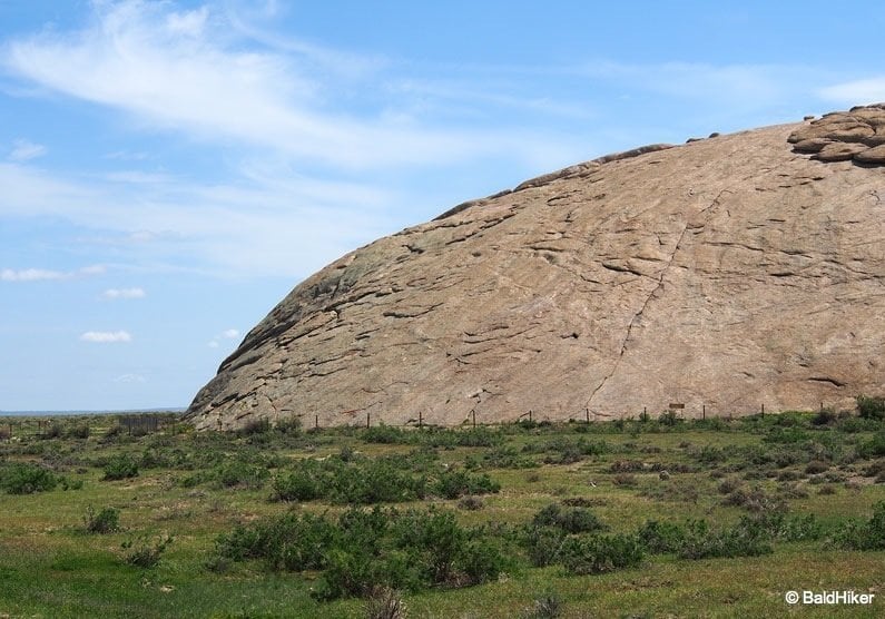
A Granite Behemoth on the Wyoming Plains
Independence Rock is a massive, oval-shaped monolith of Archean granite, an isolated peak at the southeast end of the Granite Mountains.
It stands approximately 130 to 136 feet high, measures 1,900 feet long, and is about 850 feet wide, covering nearly 25 acres.
Its story began over fifty million years ago when the peaks of the Granite Range rose.
Over millennia, the intense weight of these mountains caused them to sag, and the relentless Wyoming wind, carrying abrasive sand, smoothed and rounded their summits in a process called exfoliation.
This intense weather eventually exposed this ancient peak, creating the iconic landmark we see today.

More Than a Rock: A National Historic Landmark
Recognised for its crucial role in American history, Independence Rock was designated a U.S. National Historic Landmark on January 20, 1961, and added to the National Register of Historic Places in 1966.
It is now the centerpiece of the Independence Rock State Historic Site, owned and operated by the state of Wyoming, ensuring its preservation for future generations.
The Race Against Winter: Why Is It Called Independence Rock?
The rock’s name is tied directly to the brutal realities of the 2,000-mile journey west. The most popular and vital theory for its name is that it served as a critical deadline in a race against the seasons.
Pioneering wagon parties, who typically left Missouri in the spring, aimed to reach this landmark by July 4th—Independence Day.
Reaching the rock by this date was a sign that they were on schedule to clear the formidable Rocky Mountains and Sierra Nevada passes before the first winter snows made them impassable, a fatal miscalculation for those who fell behind.
An earlier origin story also exists. On July 4, 1830, a party of 81 fur traders led by William L. Sublette held an Independence Day celebration at the rock, and it is believed he christened it in honor of the holiday.
Regardless of which story is true, the name perfectly captures the spirit of the emigrants who travelled west seeking prosperity and independence.
“The Great Register of the Desert”: Reading the Names on the Stone
The rock’s most famous moniker, “The Register of the Desert,” was coined in 1840 by the Jesuit missionary Father Pierre-Jean De Smet.
He called it this because thousands of westward travellers had carved, painted, or written their names on its surface, turning the granite monolith into a massive, open-air bulletin board and a registry of the great migration.
Who Carved Their Names on Independence Rock?
The inscriptions represent a diverse cross-section of those who passed this way.
Native American tribes, who knew the rock as Timpe Nabor (the Painted Rock), left their own carvings and hieroglyphics.
They were followed by American fur hunters in the 1820s and, later, by the nearly half-million pioneers who journeyed on the Oregon, Mormon, California, and Pony Express Trails.
The rock was so covered in names that traveler J. Goldsborough Bruff noted in 1849 that it was “with difficulty I could find a place to inscribe it”. Some entrepreneurs even charged illiterate travellers up to $5 to carve their “autographs” for them.
Voices from the Past: Notable Inscriptions You Can Still See
Walking the trail around the base of the rock, you can still see the tangible history left by these travellers.
While many names have weathered away, some remain legible, connecting us directly to the individuals who stood in this very spot.
Documented inscriptions include one of the earliest, by M. K. Hugh in 1824, as well as later examples like Hanna Snow (1844), J. Bower (1847), R.W. Allred (1849), and R. McCord (1850).

Planning Your Visit to Independence Rock State Historic Site
A trip to Independence Rock is an easy and rewarding stop for anyone traveling through central Wyoming. Here is the practical information you need to plan your visit.
Location & Directions
The site is located along Wyoming Highway 220, approximately 55 miles southwest of Casper.
Address: Independence Rock State Historic Site, WY-220, Alcova, WY 82620.
Hours, Fees, and Amenities
- Hours: The site grounds are open 24 hours a day, year-round, though facilities are weather-permitting.
- Fees: Daily use fees are required. For 2025, the fees are $4 per adult for Wyoming residents and $8 per adult for non-residents. Children are free, and annual passes are also available. For the most up-to-date official information on hours and fees, please visit the official Wyoming State Parks website.
- Amenities: The site is equipped with restroom facilities, picnic grounds, drinking water, and a trailer dump station.
What to Do at the Site: Walking the Pioneer Trail
The primary activity is walking the one-mile loop trail that circles the base of the rock, allowing you to view the thousands of inscriptions up close.
For the sure-footed, climbing on the rock is also permitted, offering panoramic views of the surrounding plains.
The most important rule for all visitors is to help preserve this historic treasure. It is unlawful to deface, defile, or add any new markings to the rock. Please look, but do not touch the fragile inscriptions.
Independence Rock in Context: A Key Stop on the Westward Trails
Independence Rock was not an isolated feature but a key milestone in a long and arduous journey. Understanding its place in the larger narrative of the trail enhances its significance.
The Journey Along the Sweetwater River
Emigrants typically sighted the rock after leaving the major outpost of Fort Laramie and finally reaching the potable water of the Sweetwater River.
This river was a lifeline, a natural guide leading wagon trains westward through the arid plains toward the crucial South Pass over the Continental Divide.
However, the river was also a frustrating obstacle that pioneers had to cross a total of nine times.
In 1856, the icy waters of the Sweetwater near this area were the setting for the tragic events of the Willie and Martin handcart companies, who were caught in early winter storms and suffered immense loss.
Nearby Landmarks on the Oregon Trail
Just a few miles from Independence Rock is another dramatic landmark: Devil’s Gate.
This is a narrow gorge, 370 feet deep, that the Sweetwater River carved directly through a ridge of solid rock.
While wagons had to bypass the narrow cleft, emigrants often walked through the gorge and wrote about the geological oddity in their journals.
Together with Fort Laramie to the east, these landmarks formed a sequence of critical signposts on the Wyoming leg of the trail.
Conclusion
A visit to Independence Rock is more than a quick stop at a roadside attraction. It is an opportunity to stand in the footprints of history.
As you walk the path around its base and read the names faded by time, you are connecting with the resilience, hope, and monumental determination that defined the American West.
This granite behemoth is not just a register of names; it is a register of the human spirit.
Nearby Casper is home to a major interpretive center, which is managed by the Bureau of Land Management and offers extensive exhibits on the trail experience.
Other Great Rock Formations I visited during my road trip include Chimney Rock, Courthouse & Jail Rocks plus the magnificent Scotts Bluff.


