
When most international travelers visualize a classic American road trip, their minds automatically conjure images of the jagged peaks of the Rocky Mountains or the deep, sun-baked canyons of the Southwest.
Yet, if you want to understand the true, gritty reality of the historic westward migration that shaped the continent, you have to journey down the vast, sweeping plains of the North Platte River Valley in western Nebraska.
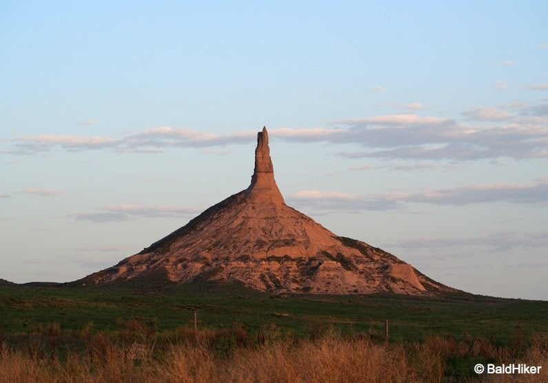
Rising dramatically out of the open grasslands is Chimney Rock.
Standing as a solitary, prehistoric spire, this iconic rock formation served as the single most famous landmark for mid-19th-century pioneers traversing the Oregon, Mormon, and California Trails.
During my own expedition tracing the historic Oregon Trail route, I made a point to arrive at the site just as the sun was clearing the horizon.

Watching the shifting dawn light illuminate the stark lines of the stone is a phenomenal experience that completely alters your view of the Great Plains.
Here is a practical guide’s manual to exploring this legendary American landmark.
🏜️ Chimney Rock National Historic Site Blueprint
Location & Address:
9807 County Road 75, Bayard, Nebraska, 69334.
Strategic Access:
Easily reached via U.S. Route 26 or Nebraska Highway 92. It sits roughly 20 miles east of the equally impressive Scotts Bluff National Monument.
The Visitor Center:
The site houses the excellent Ethel and Christopher J. Abbott Visitor Center (managed by History Nebraska), which features deep interactive exhibits, historic pioneer journals, and a museum shop.
Admission Fees:
Access to the outdoor viewing areas is free. Entry to the indoor museum exhibits requires a small admission fee (typically $3–$5 for adults, while children under 15 enter free).
The Rattlesnake Warning:
While the surrounding prairie looks inviting, do not wander off the paved viewing paths into the rough grass. The undergrowth surrounding the base of the rock is a notorious, active habitat for prairie rattlesnakes. Stick to the marked trails to stay safe.
The Most Written-About Landmark on the Trail
Long before European fur traders, trappers, and pioneers arrived on the plains, the landscape was inhabited by Native American tribes, including the Lakota Sioux.
They recognized the unique, vertical prominence of the spire and gave it a colorfully literal, cheeky descriptive name: Māni-katyú-gaju, which translates directly to “Elk’s Penis.”
By the early 1800s, the first waves of mountain men and fur trappers began mapping the river corridors.
The earliest recorded use of the name “Chimney Rock” appeared in 1827, chosen because the thin, protruding shaft perfectly replicated the look of a giant factory chimney rising out of the earth.
When the massive wagon trains of the mid-19th century began rolling west, Chimney Rock quickly became a massive psychological milestone.
It marked the official end of the flat, monotonous eastern prairies and signaled the hard transition into the rugged mountain terrain of Wyoming and the Rockies.
According to historical archives, Chimney Rock is the single most frequently mentioned landmark in the thousands of pioneer diaries and trail journals kept by emigrants.
It was a symbol of hope and progress, an unmistakable beacon that told weary travelers they were moving in the right direction.

The Geology: Clay, Ash, and Brule Sandstone
When you look at the spire close up from the visitor center terrace, you begin to appreciate the unique geological forces that carved out this lone sentinel over millions of years.
Chimney Rock was originally part of the massive, elevated cliffs and bluffs that border the southern edge of the North Platte River Valley.
Over millennia, the relentless action of wind, water, and frost completely eroded the softer surrounding earth, leaving a single, isolated column behind.

The structural makeup of the formation is split into three distinct layers:
The Base: Composed of soft, volcanic ash and heavy clay layers known as the Brule formation.
The Body: Composed of Gering sandstone blocks interlaid with loose clay deposits.
The Spire: The top chimney section survives entirely because it is capped with a much harder layer of Arickaree sandstone. This 25-million-year-old rock shield resists erosion far better than the lower layers, holding the entire pillar together.
Shifting Shapes: The Erosion Paradox
The structure currently stands at an elevation of 4,228 feet (1,288 metres) above sea level, with the spire rising roughly 286 feet from its conical base.
However, we know conclusively from early historical sketches, 19th-century photography, and pioneer descriptions that the rock was significantly taller when the first wagons rolled through.

Because it stands completely isolated on a vast plain, Chimney Rock functions as a massive, natural lightning rod for the violent summer supercell storms that sweep across Nebraska.
Over the last two centuries, multiple documented lightning strikes have shattered massive segments of the sandstone cap, while wind and rain continue to strip away the soft clay body.
It is an ever-changing landmark. Standing before it today carries a poignant sense of urgency; you are witnessing a majestic piece of natural history that is slowly, steadily dissolving back into the prairie earth.

Completing the Oregon Trail Road Trip
Arriving at the site at dawn rewards you with an unforgettable look at the scale of the American West.
The way the golden morning light shifts the colors of the stone from deep purple to blazing orange, paired with the immense, wide-open skies, perfectly showcases the raw beauty of Nebraska.

It completely disproves the common myth that the state is nothing but flat, featureless farmland.
To get the absolute most out of your regional road trip, you can easily tie your visit to two other monumental frontier landmarks located along the same highway corridor:
Scotts Bluff National Monument: Situated just 20 miles west, these massive, towering bluffs rise 800 feet over the river flats, featuring an incredible paved road and hiking trails that carry you straight to the summit overlooks.
Courthouse and Jail Rocks: Positioned roughly 15 miles south of Bayard near Bridgeport, these two massive, castle-like rock monoliths served as the very first major geological markers for pioneers entering the panhandle.
Taking the time to pull off the highway, breathe the prairie air, and trace these ancient tracks connects you directly to the spirit of exploration.
It is a powerful reminder that sometimes the best travel stories are found out in the quiet, vast spaces where history has left an indelible mark on the earth.
Explore More Historic Oregon Trail & American Wilderness Guides
- The Frontier Outpost: A Visitor’s Guide to the Shoshone-Bannock Tribes’ Fort Hall Reservation
- The Pioneer Settlement: Kansas – Old Prairie Town, Topeka: An Oregon Trail Step Back in Time
- The Expedition Send-off: The Rieger Hotel Grill & Exchange: A Historic Kansas City Feast


