
When planning a coastal trekking expedition in Wales, most hikers automatically set their compasses for the rugged cliff paths of Pembrokeshire or the extreme ridges of Eryri (Snowdonia).
However, skipping the historic southern curve of Swansea Bay means missing out on one of the most structurally unique and historically volatile maritime headlands in the country: The Mumbles.
Functioning as the official gateway to the Gower Peninsula—the UK’s very first designated Area of Outstanding Natural Beauty (AONB)—The Mumbles is a seaside village that bridges heavy industrial heritage with dramatic coastal topography.

On a recent clear morning, I packed the gear, loaded my dogs into the car, and headed down to the coast to map out the trail networks lining this famous limestone headland.
Whether you are looking for a tactical staging post before launching onto the Gower coastal paths or a rich afternoon of maritime history, here is my definitive field manual to navigating The Mumbles.
🗺️ The Mumbles Coastal Visit Blueprint
Strategic Access:
Easily reached by car via the M4 motorway. Take Junction 42 for Swansea and follow the scenic A4067 sweep directly along the edge of Oystermouth Road.
The Walking Base:
Park at the Knab Rock Car Park (Postcode: SA3 4EE). This positions you directly on the coastal path, with immediate access to the promenade, the beaches, and the historic headland trails.
Trail Distance
A level, fully surfaced 5-mile (8 km) waterfront promenade tracks cleanly from Swansea Marina straight to Mumbles Pier. From the pier, the terrain transitions into rugged, unpaved cliff paths winding around to Bracelet Bay.
The Tidal Warning:
The iconic Mumbles Lighthouse sits on the outer of two small limestone islands. At high tide, the causeway is completely submerged by the massive Bristol Channel tidal range. Never attempt to cross without checking local Coastguard tide tables.
Dog-Friendly Status:
High utility. The main promenade is an exceptional multi-use path for tracking hounds year-round, though seasonal dog restrictions apply strictly to certain sandy sections of Bracelet Bay from May to September.
Topography and Name Origins: The French “Mamelles”
As you drop down onto the coastal front, the first thing that strikes you is the imposing silhouette of the twin limestone islands sitting off Mumbles Head.
The unusual name of the village is rooted directly in this distinct geological formation.
The name “The Mumbles” tracks back to the 12th century, believed to be an anglicized corruption of the French word Mamelles—meaning breasts or rounded hills.
Early French maritime navigators charting the treacherous waters of Swansea Bay utilized these distinct, curved mounds as a primary visual landmark.
Over centuries of seafaring use, the linguistic transition from Mamelles to “The Mumbles” solidified into the local vernacular.
While the village originated as a quiet 12th-century oystering and fishing settlement, it evolved into a massive maritime transport node during the Industrial Revolution.
The headland served as a key port for exporting coal and limestone carved out of the Welsh valleys, and it played a pivotal role in the global copper trade, with the historic Mumbles Copperworks drastically reshaping the regional economy.

The Field Route: Mapping the Iconic Landmarks
Tracing the shoreline path from the village center toward the open channel carries you past a series of world-class architectural and historical features:
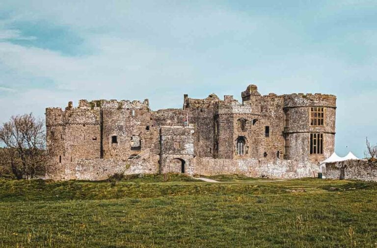
Oystermouth Castle
Perched on a high limestone ridge overlooking the village sits Oystermouth Castle, a formidable 12th-century Anglo-Norman medieval fortress.
Originally founded by William de Londo in 1106, the castle withstood multiple brutal Welsh counter-assaults over the centuries.
Walking through the restored gatehouse and exploring the ancient deep vaults gives you an incredible window into the military architecture of the Marches.
The high ramparts offer a flawless, panoramic vantage point across the entire blue arc of Swansea Bay.
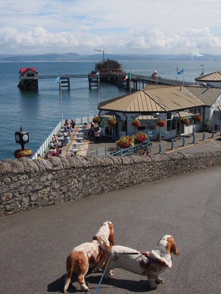
Mumbles Pier and the 1794 Lighthouse
At the absolute terminus of the paved road sits Mumbles Pier.

Originally engineered in 1898 as a elegant Victorian tourist terminal, this 835-foot iron structure served as the western terminus for the legendary Mumbles Railway—the world’s first regular passenger train service.
Directly off the tip of the pier, anchoring the outer island, is the Mumbles Lighthouse.

Built in 1794, this iconic white octagonal tower has spent over two centuries guiding commercial shipping vessels safely past the lethal sandbars of the mix-water channel.
Bracelet Bay and the Big Apple
Rounding the headland brings you into Bracelet Bay, a rugged, geologically spectacular cove framed by sharp limestone cliffs.
Right above the beach sits a brilliant piece of vintage mid-century kitsch: The Big Apple ice cream kiosk.

Built in the 1930s to promote a brand of cider, this concrete structure has survived decades of brutal Atlantic gales and remains a beloved, landmark pitstop for an outdoor scoop after a brisk coastal walk.
The Hiker’s Kitchen: Refueling Along the Mumbles Mile
A serious coastal march along the sea walls demands a proper recovery strategy. Historically, this stretch of road along Oystermouth Road was famous for The Mumbles Mile—a legendary gauntlet of seafront pubs that drew visitors from across the UK.
While the historic pub crawl has quieted down into a more refined culinary scene, the gastronomic standards here remain exceptional, heavily utilizing the local harvest from the Bristol Channel.

|
Refuel Node |
Style & Vibe |
Tactical Guide Recommendation |
|---|---|---|
|
The Pilot |
Rustic, traditional coastal pub |
Tucked on the hill, this independent pub turns out exceptional local ales and fresh, sustainably caught seafood specials in a cozy, unpretentious setting. |
|
Verdi’s Café |
Vibrant waterfront Italian parlor |
Positioned right on the promenade wall, it is an absolute institution for a hot black coffee, freshly baked cakes, or authentic handmade pasta after a cold winter walk. |
|
Patrick’s |
Contemporary Welsh dining |
A high-end, structured culinary operation that sources ingredients directly from Gower farms, delivering innovative Welsh game and seafood plates. |
If you want to sample the raw local heritage, track down a bowl of fresh, locally harvested cockles and mussels, paired with traditional Welsh laverbread (seaweed).
It is a highly nutritious, iron-dense fuel source that has sustained Welsh coastal travellers for centuries.
Launching Deeper into the Gower Frontier
Completing the loop around Mumbles Head provides the ultimate physical calibration before launching into the wider wilderness of the Gower Peninsula.
Using this headland as your primary staging node, you can seamlessly connect to the Wales Coast Path.
A brief 20-minute drive further west carries you to the jaw-dropping landscapes of Three Cliffs Bay and Rhossili, where the cliffs plummet vertically into massive sweeps of wild Atlantic surf.
The Mumbles succeeds as a travel destination because it combines technical accessibility with deep historical layers.
Walking these paths with the dogs in the sharp Welsh sunshine, surrounded by centuries of maritime engineering, is a powerful reminder of how our coastlines tell the story of Britain.
Pack your boots, keep a close eye on the tide tables, and enjoy the gateway to the wild Gower coast.
Explore More Spectacular Welsh Trails & Historic Landmarks
- The Crimson Ruins: Discovering Llandovery Castle: Ruins, Royalty, and a Welsh Hero
- The Waterfall Steam Train: Dolgoch Falls: The Walk, Parking, and Steam Train Guide
- The High Ridge Summit: A Walk Up Moel Famau: The Top Of The Clwydian Hills
- The Great Dune Trek: Hiking the Bridgend Coast Path: Merthyr Mawr Dunes to Kenfig Reserve


A place I just have to visit. Thank you for all the info, historical and otherwise.
Thank you Aidan. Yes a geat spot, truly