
There’s a certain hypnosis that takes hold when you’re driving across the vast, open plains of western Nebraska.
The sky is immense, a brilliant blue canvas stretching to every horizon, and the land is a sea of grass that seems to roll on forever.
For hours, my journey along US-26, a modern echo of the historic Oregon Trail, had been a meditation on flatness.
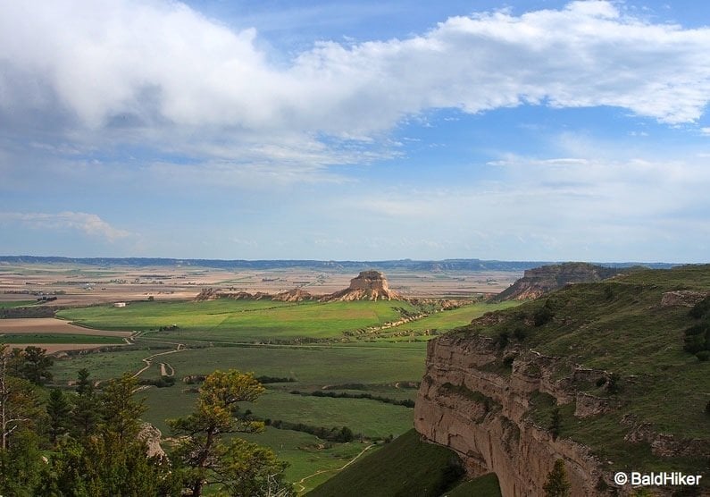
Then, I saw it. At first, it was just a smudge, a hazy, darker line against the sky.

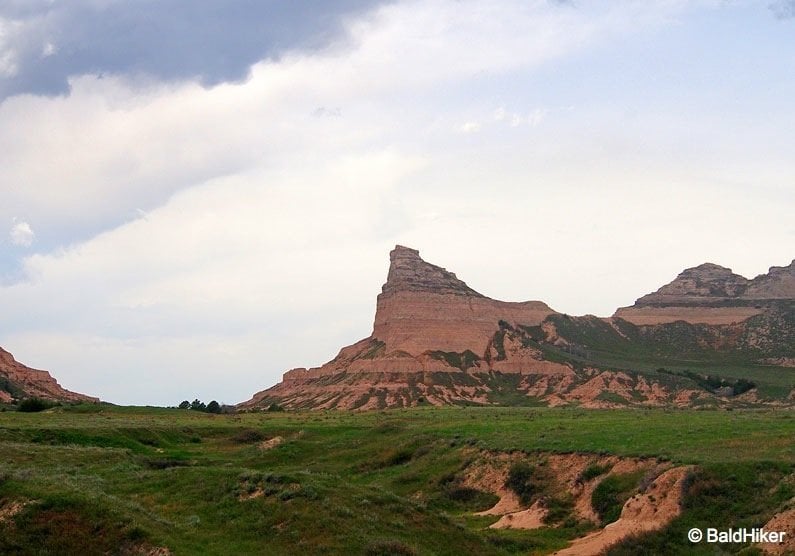
But as the miles dissolved behind me, it grew, resolving itself into a colossal, castle-like silhouette. This was Scotts Bluff, rising 800 feet from the floor of the North Platte River Valley like an ancient sentinel.
In that moment, the centuries felt paper-thin. I was just a traveller in a comfortable car, but the sight that captivated me was the very same one that had brought tears of relief and awe to the eyes of hundreds of thousands of pioneers.
I had come to Scotts Bluff National Monument not just to see a striking geological feature, but to understand its profound gravity—to walk the ground where the great story of America’s westward expansion was etched into the earth.
This place is a crossroads where deep geological time, thousands of years of Native American history, and a pivotal chapter of the American story converge.

My visit was a pilgrimage to understand why this towering promontory, a mere waypoint on a 2,000-mile journey, became a symbol of everything the trail represented: hope, hardship, and the awesome scale of the American West.
What is a Bluff? A Quick Guide for Global Readers
For my readers who might not be familiar with the term, a “bluff” is a type of large, steep hill or cliff.
Imagine a high, broad-faced promontory of rock rising dramatically from a flatter landscape, and you’ve got the right idea. A cliff but not sheer.
Scotts Bluff is a perfect example, standing as a massive formation of sandstone, siltstone, and volcanic ash that towers 800 feet above the North Platte River Valley.
These formations are essentially leftovers from a much higher ancient plain. Over millions of years, wind and water have eroded away the softer surrounding rock.
The bluffs remain because they are topped with a harder, more resistant layer of limestone called “caprock,” which acts like a protective roof for the softer layers underneath. So, when you see a bluff, you’re looking at a piece of geological history that has withstood the forces of nature for eons
More Than a Landmark: A Lifeline for Pioneers
For the more than 350,000 emigrants who journeyed west on the Oregon, California, and Mormon Trails between 1841 and 1869, Scotts Bluff was far more than just a landmark; it was a profound psychological milestone.
After enduring weeks of the monotonous, seemingly endless prairie, the sight of the bluffs confirmed they were making real progress.
It signaled the welcome end of the flatlands and the beginning of the rugged, mountainous terrain ahead, marking roughly one-third of their grueling journey complete.
The relief was palpable, a moment of renewed determination captured in countless pioneer diaries.
The sheer majesty of the formation, after so much featureless landscape, sparked the imaginations of the weary travelers.

They saw in its weathered rock faces the ruins of grand, ancient cities. In 1845, General Philip St. George Cooke marveled at the sight, calling it a “Nebraska Gibralter; surmounted by a colossal fortress and a royal castle”.
Others described seeing “domes, towers, temples, minarets, amphitheaters, frowning parapets, and even a royal bath”. One voyager was so moved as to write, “I could die here… certain of being not far from heaven”.
These romantic descriptions reveal a deep human need to find meaning and beauty amidst profound hardship.
Yet, as the wagon trains drew closer, this distant beacon of hope transformed into an immediate, formidable obstacle.
The rugged badlands and eroded gullies between the bluff and the North Platte River made passage directly along the water’s edge impossible. Initially, pioneers were forced into a long detour south through Robidoux Pass, a journey that added nine miles and a full day of travel to their already arduous trek.

In 1850, a more direct route was forged through the gap between Scotts Bluff and its southern counterpart, a passage that became known as Mitchell Pass.
In his 1851 journal, emigrant William Lobenstine noted its immediate impact: “The passage through here was only made possible in 1851 and is now preferred by nearly all emigrants, cutting off a piece of eight miles from the old road”.
Though it saved precious time, the pass, nicknamed “Devil’s Gap,” was barely wide enough for a single wagon, creating frustrating bottlenecks and forcing those behind to endure choking clouds of dust.
This constant negotiation between a distant, inspiring goal and a difficult, immediate reality defined the pioneer experience, and the bluff itself forced them to be both dreamers looking at the horizon and pragmatic problem-solvers navigating the ground beneath their feet.
The landmark also served as a somber reminder of the trail’s ever-present dangers. It was named for Hiram Scott, a clerk for the Rocky Mountain Fur Company who, according to legend, fell ill and was abandoned by his companions near the bluff in 1828.

His skeletal remains were found the following year, a grim tale that became a fixture of trail lore. Nearby, the grave of Rebecca Winters, a Mormon pioneer who died of cholera in 1852, stands as a testament to the diseases that claimed thousands of lives along the way.
Before the Wagons: The Ancient History of Me-a-pa-te
While the story of the pioneers is deeply ingrained in the monument’s identity, it represents just a sliver of the bluff’s human history.
For at least 10,000 years before the first wagon wheels cut into the prairie, this promontory was a familiar landmark for Paleo-Indian hunters following animal trails along the river.
Over millennia, it became a significant site for numerous tribes, including the Sioux (Lakota), Cheyenne, Arapaho, and Pawnee, who used the area for campsites and followed established trade routes that passed within its shadow.

These peoples had their own name for the landmark, one born from an intimate, experience-based knowledge of the land: Me-a-pa-te, which translates to “the hill that is hard to go around”.
The name is not commemorative but descriptive and functional. It speaks to a relationship with the landscape, acknowledging its power as a physical barrier that commands respect and dictates the path of travel.
The shift from the widespread use of an indigenous, descriptive name to a Euro-American, commemorative one encapsulates the broader historical narrative of the West.
The name “Scotts Bluff” imposes an external story onto the land, memorializing a single, tragic event from the perspective of newcomers.
In doing so, it subtly overwrites the millennia of history and the deep cultural connection that existed before. This change is more than linguistic; it is a powerful symbol of cultural displacement, representing the re-narrating of the American landscape from a new point of view.
A visit here is a chance to remember both histories and to understand the land through these two profoundly different lenses.
My Modern Pilgrimage: Exploring the Monument Today
My own journey to the top of Scotts Bluff was, thankfully, much easier than that of the pioneers. The experience, however, was no less awe-inspiring.
The Drive to the Heavens
The 1.6-mile Summit Road is a destination in itself. Constructed by the Civilian Conservation Corps during the Great Depression, it holds the distinction of being the oldest concrete road in Nebraska.
The drive is a marvel of engineering, winding up the steep face of the bluff and passing through three narrow tunnels blasted directly through the rock—the only such auto tunnels in the entire state.
It’s a tight squeeze, and for good reason, there are strict vehicle restrictions: no trailers are allowed, and vehicles cannot be longer than 25 feet or taller than 11 feet 7 inches.
As I navigated the sharp curves, I felt a deep appreciation for the vision and labour required to make the summit accessible to all.
Panoramas of the Plains
Reaching the summit parking area, I was greeted by a stiff prairie wind and a choice of two short, paved trails leading to spectacular overlooks.
I started with the South Overlook Trail, a short walk that provides a breathtaking, bird’s-eye view of the landscape below.
From this vantage point, I could see the entire historical diorama laid out before me: the Visitor Center nestled at the base, the distinct gap of Mitchell Pass, and the faint but unmistakable line of the Oregon Trail cutting through the prairie.
It was a powerful perspective, allowing me to grasp the sheer scale of the terrain the pioneers had to navigate.
Next, I took the North Overlook Trail, a slightly longer loop offering a panoramic vista of the North Platte River Valley and the modern cities of Gering and Scottsbluff. But the true reward was gazing east.
There, 23 miles away, was the unmistakable spire of Chimney Rock, the single most-mentioned landmark in pioneer diaries.
Seeing both iconic landmarks from one spot connected the dots of the historic trail, collapsing the immense distance into a single, stunning view and driving home the reality of the pioneers’ slow, landmark-to-landmark crawl across the continent.
Walking Through Time: Hiking the Historic Trails
While the views from the summit are magnificent, the true heart of Scotts Bluff is found on its trails. The monument’s network of paths offers more than just exercise; it provides different ways to physically and emotionally connect with the past.
The drive to the summit offers an intellectual appreciation of the site’s history, but to truly feel its weight, you have to get out and walk.

The Oregon Trail Pathway
I started with the Oregon Trail Pathway, a roughly 1-mile round-trip walk that begins near the Visitor Center. The path leads past several replica Conestoga wagons, giving a sense of the pioneers’ mobile homes.
But the real magic happens when the pavement ends. I found myself standing on the bare earth of the original trail, in the very swales—the deep, lasting ruts—carved by the iron-clad wheels of hundreds of thousands of wagons.
Standing in those depressions, I could close my eyes and almost hear the creak of wood, the lowing of oxen, and the murmur of voices speaking of hope and fear.
It is one of the most tangible, powerful connections to American history I have ever experienced—a physical scar on the land that tells a story of immense human endeavor.
The Saddle Rock Trail
For a more physical challenge, I tackled the Saddle Rock Trail. This 3.2-mile round-trip hike is the monument’s most strenuous, gaining about 435 feet in elevation as it switchbacks from the Visitor Center to the summit.
The trail is paved but steep, especially in the upper sections. It’s almost entirely exposed to the sun, making an early start and plenty of water an absolute necessity on a warm day.
The effort is rewarded tenfold. The trail offers intimate, ground-level views of the bluff’s dramatic rock formations and passes through a small foot tunnel that was a practice run for the larger tunnels on Summit Road.
This hike provides a different kind of empathy—a physical understanding of the verticality and ruggedness of the terrain that the pioneers had to contend with every single day.
A Story Told in Stone and Sky
Scotts Bluff is a living museum, its stories told not just in exhibits but in the very rocks and the ecosystem they support.
The Making of a Monument
The geological story of Scotts Bluff is as epic as its human history. The tale begins over 30 million years ago, when ancient rivers and winds carried sand, silt, and volcanic ash from distant eruptions in present-day Colorado and the Great Basin, depositing them in layers across the high plains.
Over eons, these layers were compressed into the sandstone and siltstone we see today.
The key to the bluff’s survival lies in its “caprock”—a harder, more resistant layer of limestone that formed near the surface.
As millions of years of erosion wore away the surrounding softer rock, this durable cap protected the layers beneath it, leaving Scotts Bluff and its famous neighbours, Chimney Rock and Courthouse Rock, standing tall against the forces of nature.
The Living Prairie
The 3,000 acres of the monument protect a vibrant mixed-grass prairie ecosystem. The landscape is dominated by native grasses like little bluestem and buffalo grass, while the cooler, shadier slopes of the bluff support ponderosa pine and Rocky Mountain juniper.
In the spring and summer, the prairie comes alive with the color of wildflowers, including common sunflowers, showy milkweed (a vital host for monarch butterflies), and vibrant purple penstemon.
This habitat supports a surprising diversity of wildlife. You may well see a small herd of mule deer grazing near the river and the charming antics of a prairie dog town.
Other common residents include eastern cottontails and fox squirrels.
While exploring, it’s crucial to be aware of the monument’s less cuddly inhabitants. Prairie rattlesnakes are common here and are very well camouflaged. For your safety and theirs, always stay on designated trails and be aware of your surroundings.

Your Guide to the Trail: Planning Your Visit to Scotts Bluff
A trip to this historic landmark is straightforward and incredibly rewarding. My first stop, and what I recommend for everyone, is the Oregon Trail Museum and Visitor Center at the base of the bluff.
Inside, you’ll find excellent exhibits on the geology and paleontology of the area, as well as the rich human history of the westward trails.
A true highlight is the world’s largest collection of paintings and photographs by William Henry Jackson, a pioneer artist who travelled the trail himself and whose work provides an invaluable visual record of the journey.
Be sure to also grab your National Park Passport and collect the five different stamps available here.
Plan Your Visit: Scotts Bluff National Monument at a Glance:
Location: 190276 Old Oregon Trail, Gering, NE 69341
Entrance Fee: None
Park Grounds & Trails Hours: Sunrise to Sunset Daily
Visitor Center Hours: Varies by season (Summer: 8:00 AM – 6:00 PM; Rest of Year: 8:30 AM – 4:30 PM)
Summit Road Hours: Varies by season (Summer: 9:00 AM – 5:30 PM; Rest of Year: 9:00 AM – 4:00 PM)
Summit Road Restrictions: No trailers. Vehicles must be < 25 ft long and < 11 ft 7 in high
Pets: Leashed pets are permitted on all paved trails
Accessibility: Visitor Center, picnic areas, and summit overlook trails are largely accessible. A wheelchair is available for use. See NPS site for details.
For a deeper dive into the region’s agricultural past, the Legacy of the Plains Museum is just a mile away. The adjacent towns of Gering and Scottsbluff offer a full range of lodging and dining options, from comfortable hotels to local breweries like Flyover Brewing Company and charming cafes like The Mixing Bowl.

Conclusion: An Echo Across the Plains
Leaving Scotts Bluff, with its monumental silhouette shrinking in my rearview mirror, I felt a profound sense of connection. Coming from the UK it was the like of something had not felt before on UK peaks.
This is more than just a beautiful park or a historical site; it’s a place where you can feel the deep currents of time. You can stand on rocks that witnessed the age of mammals, walk in the footsteps of people who gambled everything for a new life, and watch a prairie sunset that has remained unchanged for millennia.
Scotts Bluff is an echo across the plains—an echo of geological upheaval, of ancient bison herds, of Native American councils, and of the creaking wheels of half a million dreams heading west.
I encourage you to make your own pilgrimage. Come not just to see a landmark, but to listen to its stories and to feel, for a moment, the enduring spirit of the trail.


I spent 4years in Scottsbluff going to the now defunct Hiram Scott College. I hiked the trail up the bluff several times and rode up too. The view is spectacular, breathtaking. Miles and miles of of visible beauty and you were privileged to watch a storm move across the landscape. I am from Pennsylvania living in Ohio and have made 4 trips back to see it
Thanks for the post! Will be going in the fall, and now with a better reason.
thanks Stephen
Beautiful pics and love the story behind the name. You never bore me and always keep me coming back for more. Have a wonderful day Paul.
Very cool! I always think of Nebraska as being flat and forget that the landscape changes in the west. Would love to follow the Oregon Trail one day!