A return to a favourite area for walking, Great Asby Scar and the surrounding high land. It is one of those little parts of Britain that I return to again and again, plus whatever the weather it produces wonderful memories in the great outdoors. Another great aspect to this walk is it is never busy at all, one of the quietest walking areas of Cumbria.

Situated between the Cumbrian Villages of Orton and Great Asby, the land you are roaming here is filled with amazing geology, history and views. No wonder I keep heading back for more. This walk I have shown in more detail in a previous post, regarding the historical spots and the views from ground level, but this time I had the Mavic Air drone in my backpack so thought a good way to show from the air.

The limestone paving of Great Asby Scar is remarkable. When people think of a huge expanse of limestone paving they immediately get drawn to Malham Cove, after all it is the largest. But also where the masses go. Great Asby Scar together with Orton Scar is one of the best natural limestone pavings to walk, as well as being one of the largest. (be careful over the rocks).

What causes natural limestone paving like this? Well, the last ice age over 10,000 years ago took away the top layers of earth exposing the limestone as the glaciers retreated. Limestone is not the hardiest of stone, so rain plus the elements have gradually, over the many centuries, created fissures amongst it all. The fissures are called grykes and the blocks of stone that you walk upon are called clints.

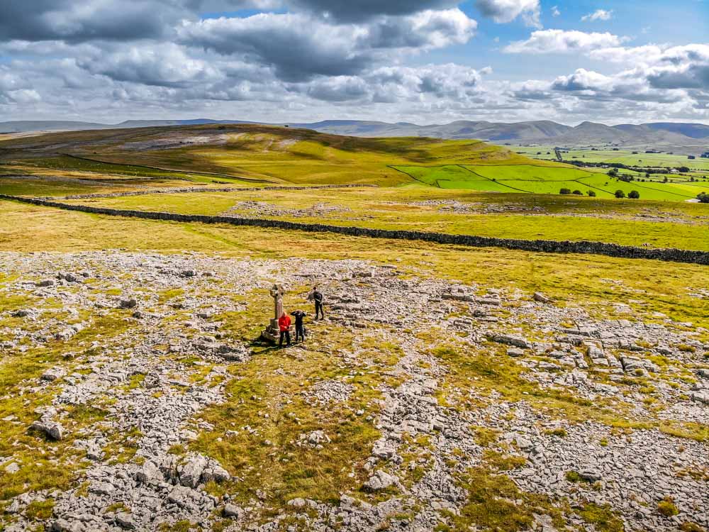
Amongst the limestone paving is a remarkable historical structure that can be seen even better from the air. The Castle Folds Settlement, a Romano-British stone hut circle settlement.

A very unique British-Romano Settlement. Up here on the tops, up on the hills amongst this limestone paving. Quite inaccessible in relation to other settlements of the period. These settlements were normally set up as a place to live for non Roman British natives, 2 thousand years ago. This one seems though to have been more heavily fortified and the location up on the scar adds to inaccessibility. There must have been a high level of threat to those living here. In medieval times the settlement was known to have been used as shelter for locals avoiding attacking Scots.

The highest point of Great Asby Scar is The Knott at just 412m (1352 feet). Views are expansive, with the Howgills all across in one direction, the mountains of the Lake District over the other way in the distance. Plus over a third way you can see the wondrous North Pennines. Hills in every direction. A beautiful spot for a pause. With this area being so quiet you can enjoy it all in quiet contemplation.

Looking at it from the air gave me a whole new aspect to a walk I love to do. It is a ‘no set route’ kind of area. A place to explore and see and learn. If you meet anybody walking around here they are more likely to be dog walkers who have driven from the surroundings. See, they know. In fact I learnt the area a lot when I used to wander with Monty and Jasmine, the twin Bassett Hounds I miss a lot.
To get up here you can take the path up from Orton village, or you can start up on the B6260 (Appleby road from Orton). A couple of car parks are on the top road here. And paths lead in many directions. Walk any path eastwards and take it all in.

It doesn’t involve high peaks, it doesn’t involve big climbs, but you really feel you have spent a good day out in the fresh air on Orton and Great Asby Scar. It is unique in its landscape, unique in its geology and unique in its history.
After a day on the Scars of Orton and Great Asby it was a perfect time to get back to our accommodation, kick off the boots and take a look at the footage from a grand day out once more.