The 12-day Annapurna Circuit trek in Nepal is widely considered one of the single greatest long-distance wilderness achievements in the world.
Circuiting around the colossal Annapurna Himal massif in the central Himalayas, this trail is stunningly beautiful, physically demanding, and an outdoor adventure that will alter your perspective on travel forever.
It is one of the few places on Earth where you can experience almost every single climatic zone in a short geographical window.

You will start in the humid, sub-tropical rice paddies of the Himalayan foothills, climb through temperate rhododendron and pine forests, push up into the barren, alpine climes of the Manang Valley, and ultimately cross into the arctic zone over one of the highest trekkable mountain passes in the world: the Thorong La Pass at 5,416 metres.
Because this trek is an immense physical undertaking that requires careful acclimatisation and planning, tackling it demands an organized, day-by-day strategy.

Drawn from my own boots-on-the-ground expedition diary, here is the complete stage-by-stage manual to navigating the full Annapurna Circuit.
🎒 The Annapurna Circuit Route Matrix
|
Trekking Phase |
Core Route Stages |
Key Highlights & Elevation Milestones |
|---|---|---|
|
Act I: The Foothills |
Kathmandu ➔ Besisahar ➔ Ngadi ➔ Jagat ➔ Chame ➔ Bhratang |
Sub-tropical gorges, mica-dusted trails, and the organic apple orchards (2,850m). |
|
Act II: The Alpine Valley |
Bhratang ➔ Pisang ➔ Manang ➔ Letdar ➔ Thorong Phedi |
Acclimatisation walks, the shadow of Mount Manaslu, and high altitude rest steps (4,450m). |
|
Act III: The High Pass |
Thorong Phedi ➔ Thorong La Pass ➔ Muktinath ➔ Jomsom ➔ Pokhara |
The 5,416m summit push, 1,600m knee-jarring descent, and the flight out of the mountains. |
Act I: Kathmandu to the Bhratang Apple Orchards (Days 1–4)
The Overland Transit to the Marshyangdi Valley
The adventure kicks off long before you lace up your boots.

Arriving in the tropical, 27°C heat of Kathmandu, the contrast against the heavy down jackets in your duffel bag is immediate.
After a traditional welcome from your local guide and a critical pre-trek safety briefing, the journey into the interior requires a grueling, 6:30 AM jeep transit.
The drive from Kathmandu to the trailhead at Besisahar is a long, hair-raising, and bone-jarring journey tracking the path of the roaring Trishuli River.

If you happen to travel at the start of the Dashain Festival—a major regional celebration when millions of Nepalese travel back to their homelands—the roads transform into a massive exodus of locals, goats, and chickens.

From Besisahar, you pick up your porters, transfer jeeps, and follow the steep walls of the Marshyangdi River Valley to the opening village of Ngadi (920m) to settle into your very first traditional mountain tea house.
Moving Through the Sub-Tropics: Ngadi to Jagat
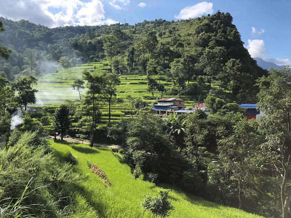
The opening leg of the foot trek plunges you into a dense, humid sub-tropical paradise.
The air is filled with a deafening, almost mechanical hum of local cicadas that sounds remarkably like an unoiled fan belt echoing through the trees.

The path tracks along unique, shale-heavy trails where the high mica content causes the earth to glitter underfoot, coating your hiking boots in a fine layer of silver dust.
Wildflowers line the path in abundance, including exotic orchids, blooming hibiscus, and massive shrubs of Angel’s Trumpets hanging over the roaring river.

Safety is paramount here; the trail frequently crosses active, wet landslide zones carved out by recent monsoon rains.
Moving efficiently through these exposed paths without stopping is vital.

After passing Ghermu and looking across at the spectacular, tumbling columns of Syange Falls, you cross your first major Himalayan suspension bridge before a final, steep incline carries you into the stone canyon village of Jagat (1,300m).

The Climb into the Pine Forests: Jagat to Chame & Bhratang
The push from Jagat onward is a long, physically demanding mountain haul that highlights the absolute necessity of a high-calorie nutrition strategy.
Fueling a full day of steep climbs requires a serious carbohydrate foundation at breakfast—a simple egg omelette will not cut it when your body is burning thousands of calories.

Switch out standard tea for sweet, hot Masala Tea or fresh ginger tea to keep your stamina high.
As you approach Bagarchap (2,160m), you will encounter the fast-moving, jangling mule trains that serve as the primary cargo lifelines for the upper mountains, transporting gas cylinders and expedition gear down from the high passes.
Always stay on the mountainside of the track when a mule train passes—never stand on the exposed cliff edge side, as a single accidental nudge from a heavy pack can be catastrophic.
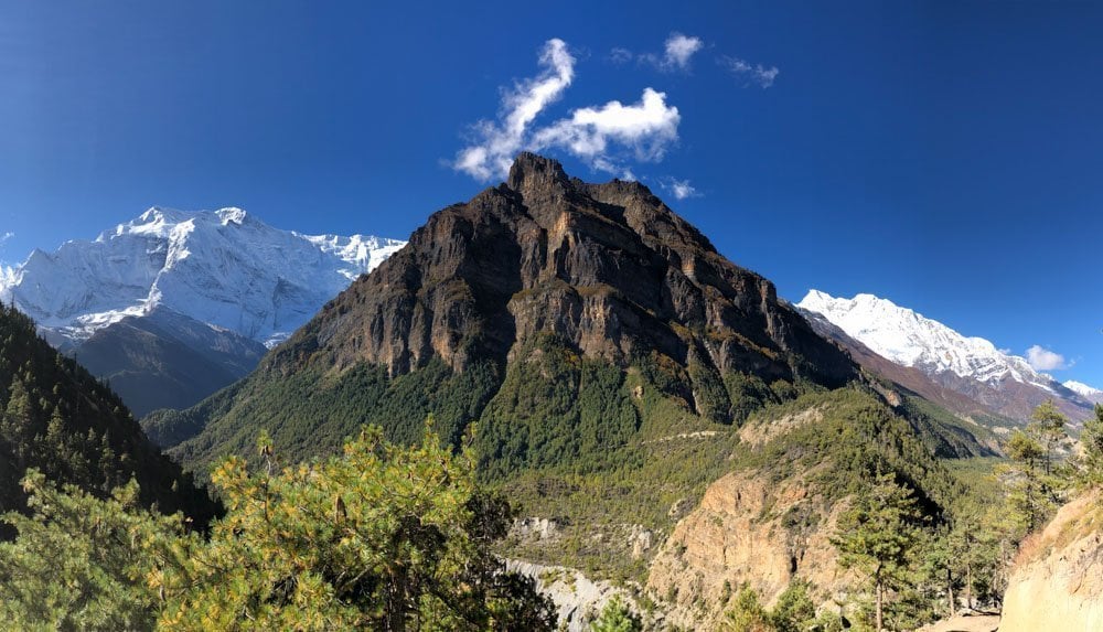
Waking up the next morning rewards you with your very first glimpse of a true Himalayan giant: Mount Manaslu.
Standing at a staggering 8,163 meters, the world’s eighth-highest mountain serves as a breathtaking backdrop as you leave the sub-tropical humidity behind, replaced by the crisp, cool air of the Manang Valley’s alpine pine and fir forests.

A final, short hike from Chame carries you through a dramatic section of the path blasted directly out of a sheer, vertical rock wall hanging right over the churning river canyon below, before emerging into a surprising alpine oasis: the Bhratang Apple Orchards (2,850m).

Dropping your pack at the local organic farm’s lodge allows you to reward yourself with a hot, freshly baked slice of local Himalayan apple pie—the ultimate milestone to mark the completion of your opening phase.

Act II: Acclimatisation and the Upper Alpine Barrens (Days 5–8)
Entering the High Valley: Bhratang to Manang
Leaving the orchards behind with apple pie in your stomach, the trail enters the upper tier of the Manang District.
The landscape changes dramatically once more; the dense pine forests begin to thin out, transitioning into a wide, windswept alpine valley flanked by the sheer, icy walls of the Annapurna Massif.

The trek carries you through the traditional stone villages of Upper and Lower Pisang, where the architectural style shifts to flat-roofed stone houses designed to withstand heavy winter snowfalls.
Here, the cultural tapestry flips from the Hindu traditions of the lower foothills to Tibetan Buddhist heritages.

The trails are lined with long, spinning rows of brass prayer wheels and thousands of vibrant, wind-snapped prayer flags carrying blessings across the mountain gaps.

By the time you reach the major mountain hub of Manang (3,540m), you are officially entering the high-altitude zone.
The air contains significantly less oxygen, and your body will begin to notice the initial signs of atmospheric pressure shifts.

The Mandatory Rest: Acclimatisation in Manang
To safely conquer the Thorong La Pass without succumbing to acute mountain sickness (AMS), spending a mandatory acclimatisation rest day in Manang is a non-negotiable safety rule.
The golden rule of high-altitude trekking is “climb high, sleep low.”

During your rest day, lace up your boots for a steep, slow conditioning hike up the valley walls to view the spectacular, icy tongue of the Gangapurna Glacier and its turquoise meltwater lake.

Climbing up to 3,800 meters before descending back to Manang to sleep triggers your body to produce the vital red blood cells needed to process the thin air.
Use the remainder of the day to attend the daily high-altitude safety lecture delivered by volunteer doctors at the Himalayan Rescue Association (HRA) post, pack your pockets with locally baked pastries, and rest your legs.
Pushing into the Arctic Gateway: Manang to Letdar & Thorong Phedi
Leaving Manang, the trail leaves all trees behind.
The environment shifts into a stark, Martian-like alpine tundra dominated by low juniper shrubs, grey scree slopes, and skeletal rock ridges.

The daily trekking distances become shorter, but the physical effort doubles as you enter the high valley toward Letdar (4,250m).
At this elevation, the simple act of rolling over in your sleeping bag or tying your boots can leave you completely breathless.
The nights become bitterly cold, dropping well below freezing, requiring you to tuck your water bottles and camera batteries deep inside your sleeping bag to keep them from freezing solid.
The final step of Act II is the slow, rhythmic march from Letdar to Thorong Phedi (4,450m) or the High Camp (4,925m).

The path snakes along a narrow, crumbling scree slope exposed to rockfalls.
Your team guides will conduct strict health checks here, monitoring your pulse and blood oxygen ($O_2$) saturation levels via a pulse oximeter.
Fuel up on a massive bowl of garlic soup—a legendary local mountain remedy for expanding blood vessels and combating altitude headaches—and head to bed early. The mountain pass is waiting.

Act III: Over the Mighty Thorong La Pass to Jomsom (Days 9–12)
The Alpine Summit Push: Crossing 5,416 Metres
Day 10 is the definitive crucible of the entire circuit. The wake-up call hits at a brutal, freezing 3:30 AM.
After forcing down a high-calorie breakfast of apple pancakes and hot ginger tea in the dark, you step out into the sub-zero arctic air under a spectacular blanket of Himalayan stars, your head torch illuminating the frozen, snowy switchbacks ahead.

The climb from High Camp to the summit of the Thorong La Pass (5,416m / 17,769 feet) is a test of pure mental resilience.

Every single step requires a deliberate, synchronized breath. The landscape is a monochrome world of rock, ice, and thin air.

But when you finally round the final crest and see the iconic, snow-draped chorten festooned with thousands of colorful Buddhist prayer flags, the euphoria is absolute.

Standing at the top of one of the highest trekking passes in the world, surrounded by the soaring, sunlit peaks of the Dhaulagiri and Annapurna ranges, is a profound, tear-filled milestone.

The Punishing Descent to Muktinath
You cannot linger at the summit for more than 30 or 40 minutes; the extreme altitude and volatile mountain winds mean you must begin the descent quickly.
The trek down from the pass into the Mustang District is a brutal, knee-jarring 1,600-metre vertical drop over loose shale and steep snowfields.

This is where a high-quality pair of trekking poles transitions from an optional luxury into an absolute joint-saving necessity.
After nearly 10 hours of intense trekking, the trail levels out into the grassy meadows of the Jhong Khola Valley, carrying you into the sacred pilgrimage oasis of Muktinath (3,800m).

This ancient site is deeply revered by both Hindus and Buddhists, bustling with vibrant crowds of pilgrims visiting the eternal natural gas flame and the 108 sacred water spouts
Celebrate your achievement like our mountain family did: with a hot shower, a cold Gurkha beer, and a massive celebratory yak steak served with a side of proper chips.

The Dusty Finish: Jomsom, Pokhara, and Back to Kathmandu
The final leg of the loop tracks down through the vast, windswept gravel flats of the Kali Gandaki River Valley into the bustling, dusty transport hub of Jomsom.

The valley is famous for its fierce afternoon gale-force winds that tear through the river canyons, blowing up clouds of grey sand.
Keep your eyes on the river stones to spot saligrams—140-million-year-old fossilized ammonites that pilgrims treasure as sacred manifestations of the god Vishnu.
The adventure finishes with a thrilling, spectacular mountain flight out of Jomsom’s tiny airstrip.

The small propeller plane glides directly between the massive walls of the Annapurna and Dhaulagiri chasms, dropping you into the lakeside paradise of Pokhara for a celebratory afternoon boat ride before a final flight returns you to the colorful chaos of Kathmandu.


Giving Back: Chance for Nepal
Trekking through these mountains is a privilege made possible entirely by the immense strength, warmth, and hospitality of the Nepalese people.
Ahead of our expedition, our group established a dedicated charity drive for Chance for Nepal—an incredible, small-scale UK charity that bypasses corporate bureaucracy to deliver direct, sustained aid, medical support, and educational training to vulnerable families across the country.
Thanks to the immense generosity of our community, we raised nearly £1,931.
These funds have gone directly to the front lines, completely filling the water infrastructure tanks at Papa’s Home in Lalitpur to secure clean water for an entire year, alongside funding a young girl’s education at the Sapana School in Chitwan for two years.

If these mountains touch your heart, consider checking out their work to support the communities that make the Annapurna Circuit possible.
Explore More Spectacular High-Altitude Wilderness Treks
- The Nepalese Giant: Climbing Mera Peak: Stepping from Trekking into Mountaineering
- The Indian Himalayas: The Tapovan Expedition: Trekking to the Sacred Source of the Ganges
- The Bhutanese Sanctuary: A Hike To Tiger’s Nest Teahouse, Bhutan

Nice post! Very well written and enjoyable to read.
Hi Ashley
What a lovely journal, sounds like you guys hiked all the way up to Manang, and skipped the 4wd. Few years ago, i took a jeep ride from Besishar to Manang, and it was really rough. Due to massive flood this year 2021, the trail and roads, everything has been washed .. thanks for sharing your experience
Hi there Nima, thank you so much for your kind words about my blog. Do check out blogs 2 and 3 in the series. We trekked all the way to Jomsom, the only bit in jeeps was at very beginning from KTM to first stop. It was truly a trip of a lifetime and I long to go back to Nepal it has captured my heart. Very sorry to hear of all the flooding, seems to be happening everywhere lately