There are some journeys that are measured not just in miles, but in the depth of the experience. They are conversations held between footfall and ancient stone, between the burn in your legs and the vast, sweeping sky.
The Yorkshire 3 Peaks Challenge is one such journey. It is a formidable undertaking, a celebrated rite of passage for British walkers, but to see it merely as a physical test is to miss the point entirely.
This is an invitation to step into one of the UK’s most profound landscapes and discover something of its character, and in doing so, something of your own.
The challenge calls you to the fells of Pen-y-ghent, Whernside, and Ingleborough—three distinct giants that dominate the skyline of the Yorkshire Dales National Park. Each possesses a unique personality, a different story etched into its slopes by millennia of ice, wind, and rain.
To walk this 24-mile circuit is to trace the footsteps of generations, to feel the wild, windswept mood of the high tops and the quiet tranquillity of the valleys below.
This guide is built on a philosophy of mindful adventure; it is about preparation, respect, and presence. It provides the expert knowledge and meticulous planning needed to undertake this challenge safely and confidently, allowing you to immerse yourself in the journey.
Because the true achievement is not just in reaching the final summit, but in being present with every single step along the way.

1. Understanding the Challenge: More Than Miles and Mountains
Before the first boot is laced, it is essential to understand the nature of the undertaking. The Yorkshire 3 Peaks Challenge is a serious endeavour, demanding respect and preparation.
Yet, its identity has long been a subject of quiet debate: is it a race against the clock or a profound journey through a storied landscape?
The most rewarding approach lies in seeing the latter as the true purpose, and the former as a measure of good planning.

The Task at Hand: The Mission Briefing
In its simplest terms, the challenge is a single-day, circular trek that summits the three highest peaks in the Yorkshire Dales. The statistics provide a clear measure of the physical demands:
- Distance: Approximately 24 to 24.5 miles (38.6 to 39.5 km), depending on the exact route taken.
- Total Ascent: Around 1600 metres (approximately 5,200 feet) of vertical climb over the course of the day.
- Time Goal: The traditional benchmark for completion is under 12 hours.
This combination of distance and ascent makes it one of the most formidable single-day walking challenges in England.

A Storied Past: The Footsteps of Generations
The route is steeped in history, a path worn by drovers, farmers, and adventurers. While the landscape was carved by glaciers at the end of the last Ice Age, the challenge itself has a more recent, yet distinguished, lineage.
The first recorded completion of the three-peak circuit was in July 1887 by two local schoolteachers, J.R. Wynne-Edwards and D.R. Smith, who finished in a remarkable 10 hours.
It is important to distinguish this traditional walking challenge from the official Three Peaks Race. The fell race, a gruelling athletic event, was first held in 1954 and has its own separate history and records.
The walking challenge, however, has always carried a different spirit. This distinction was famously articulated by the legendary fell-walker Alfred Wainwright, who lamented that, “Some participants have chosen to regard the walk as a race, and this is to be greatly regretted, walking is a pleasure to be enjoyed in comfort”.
This sentiment captures the essence of a mindful approach to the fells.

The BaldHiker Approach: It’s Your Journey, Your Pace
The 12-hour target should not be viewed as a rigid, pass-fail examination. Instead, it is a testament to effective preparation, solid fitness, and efficient navigation.
Achieving it is a satisfying accomplishment, but it should be the result of a well-executed journey, not the sole, frantic purpose of it. The landscape of the Dales demands to be experienced, not just rushed through.
Success on the Yorkshire 3 Peaks is personal. It may be finishing in under 10 hours, or it may be simply completing the circuit in 14 hours, having pushed personal boundaries and finished safely.
The aim is to find the joy in the challenge and the beauty in the moment. By focusing on meticulous planning and preparation, a walker is freed from the stress of the unknown, able to lift their head and connect with the incredible environment they are moving through.
This guide is designed to empower that experience, framing the 12-hour goal not as a finish line to be sprinted for, but as a benchmark that a well-prepared and mindful walker can achieve while fully appreciating the journey.
2. Meet the Peaks: The Three Giants of the Dales
To undertake the challenge is to become acquainted with three of England’s most iconic hills. Each has its own distinct character, shaped by a unique geological makeup and a rich history. They are not simply obstacles to be overcome but ancient entities to be understood and respected.

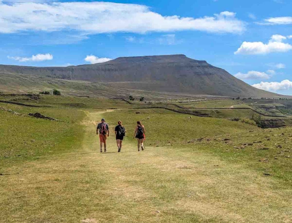
Pen-y-ghent: The Guardian at the Gate (694m / 2,277 ft)
Often described as the most dramatic of the three in appearance, Pen-y-ghent stands like a crouching lion or the prow of a great ship, guarding the entrance to the challenge. Its name, possibly from Cumbric or Welsh, is thought to mean ‘Hill of the Winds’ or ‘Hill on the Border’, both of which feel apt when you are exposed on its summit.
As the first peak on the traditional anti-clockwise route, it serves as an early and abrupt test of a walker’s resolve.
The ascent from the south is steep, involving a short, sharp scramble up its terraced face that gets the heart pumping and warms the legs for the long day ahead.
Geologically, it is a classic Dales peak, with a protective cap of hard millstone grit sitting atop softer layers of carboniferous limestone.
This structure gives it its distinctive, stepped profile. The mountain is also riddled with fascinating geological features, including the cavernous chasms of Hunt Pot and Hull Pot, the largest natural hole in England, where a stream plunges dramatically into the underworld.

Whernside: The Roof of Yorkshire (736m / 2,415 ft)
At 736 metres, Whernside holds the title of the highest point in the ceremonial county of North Yorkshire. Unlike the dramatic profiles of its neighbours, Whernside presents itself as a long, gracefully curved ridge, often described as a ‘whale-back’.
What it lacks in pointed drama, it more than makes up for in scale and perspective.
The challenge of Whernside is one of endurance. The ascent is a long, steady, and winding climb rather than a short, sharp shock.
The path famously runs alongside the magnificent Settle-Carlisle railway line, and the sight of the Ribblehead Viaduct from its slopes is one of the defining images of the Yorkshire Dales.
The reward for this long haul is a breathtaking panorama. On a clear day, the views stretch west across to Morecambe Bay and the shimmering Irish Sea, and north towards the fells of the Lake District.
An interesting piece of trivia for those who reach the summit trig point is that they are, for a moment, standing just inside the county of Cumbria, as the historic border runs along the spine of the ridge.

Ingleborough: The Fortress on the Hill (723m / 2,372 ft)
Ingleborough is the second highest of the three peaks, but it is arguably the most loved. Its commanding presence and distinctive, flat-topped summit plateau give it the appearance of a vast natural fortress.
As the final major ascent of the challenge, it is a formidable test for tired legs, but summiting it brings an immense psychological reward.
The mountain’s unique, stepped profile is a direct result of its geology—alternating layers of hard limestone and sandstone with softer shales, all protected by a cap of millstone grit.
This geology has created a classic limestone landscape, with the mountain surrounded by some of the finest examples of limestone pavement in the UK.
The summit itself is a place of deep historical resonance. The remains of a huge Iron Age hillfort, once belonging to the Brigantes tribe, are still visible, adding a layer of ancient human history to the natural grandeur.
Navigation on the broad, half-mile circumference of the plateau can be notoriously difficult in poor visibility, demanding careful use of a map and compass.

The Peaks at a Glance
For quick reference, the core characteristics of each peak are summarized below. This data provides the raw metrics, but the true nature of each is only revealed by the journey itself.
| Peak | Height (Metres) | Height (Feet) | Defining Characteristics & Key Features |
| Pen-y-ghent | 694m | 2,277 ft | Dramatic, steep southern ascent; “Hill of the Winds”; features Hull Pot. |
| Whernside | 736m | 2,415 ft | Highest point in Yorkshire; long, whale-backed ridge; views of Ribblehead Viaduct. |
| Ingleborough | 723m | 2,372 ft | Flat-topped “fortress”; site of an Iron Age hillfort; surrounded by limestone pavement. |
3. Meticulous Planning: The Foundation of a Great Adventure
Success in any significant outdoor undertaking is built not on brute force, but on meticulous preparation. A background in military planning teaches one that foresight and attention to detail are paramount; they create the conditions for a safe and successful mission.
This principle applies directly to the Yorkshire 3 Peaks. By managing the logistics in advance, a walker is free to focus on the experience, secure in the knowledge that they are prepared for the day ahead.

Choosing Your Season: A Four-Part Briefing
The character of the Dales changes dramatically with the seasons, and selecting the right time of year is the first critical decision.
Spring (April – May): Often considered the ideal season. The daylight hours are long, the fells are awakening with new life, and the main summer crowds have yet to arrive. However, the weather is notoriously unpredictable; sunshine can give way to snow showers with little warning, so full waterproofs and warm layers are essential.
Summer (June – August): This period offers the longest daylight hours and the best chance of stable, warm weather. The downside is the route’s immense popularity. On summer Saturdays, hundreds of walkers can be on the trail, which can detract from the sense of wilderness. The heat can also be a significant factor, demanding an increased focus on hydration.
Autumn (September – October): A wonderful time to be on the hills. The light is often golden, the air is crisp, and the crowds begin to thin. Daylight becomes a more critical factor, and an early start is vital. For walks in October, a headtorch becomes a mandatory piece of safety equipment as the chances of finishing in the dark increase significantly.
Winter (November – March): Undertaking the challenge in winter (after snow) is a serious mountaineering objective and should only be attempted by experienced walkers with the appropriate skills and equipment for ice and snow, including crampons and an ice axe. The conditions can be severe, but for those who are prepared, the reward is a landscape of stark, frozen beauty.

Logistical Strategy: Travel, Parking, and Base Camp
The practicalities of getting to and staying in the area require careful thought, as they can be a significant source of stress if left to the last minute. The popularity of the challenge has placed considerable strain on local infrastructure, particularly in the main starting village.
Travel and Start Points: The traditional starting point is the village of Horton-in-Ribblesdale. However, there are two other excellent options. Ribblehead, near the famous viaduct, and Chapel le Dale offer quieter starts. A highly recommended and sustainable travel option is the Settle-Carlisle railway line, which has stations at both Horton-in-Ribblesdale and Ribblehead, allowing walkers to arrive without a car.
Parking: This is a critical issue. The main National Park car park in Horton-in-Ribblesdale (postcode BD24 0HE) fills up extremely early on weekends. The daily charge is around £4.50. Several local farmers open their fields for overflow parking for a small fee, which is a good alternative. It is imperative to park considerately and legally, avoiding residential streets, gateways, and verges. The influx of vehicles is a source of significant friction with the local community, and responsible parking is a key part of being a respectful visitor.
Accommodation: The area offers a wide range of accommodation, but booking well in advance, especially for spring and summer weekends, is essential.
Pubs & Hotels: For comfort and a hearty meal, establishments like The Golden Lion and The Crown Hotel in Horton-in-Ribblesdale, The Station Inn at Ribblehead, and the Old Hill Inn in Chapel le Dale are perfectly situated.
Bunkhouses & Hostels: Ideal for groups and those on a budget. The 3 Peaks Bunkroom in Horton, The Old School Bunkhouse near Ingleborough, and the YHA in nearby Ingleton are popular choices.
Campsites: For those wishing to be closer to the elements, Holme Farm campsite in Horton and Knight Stainforth campsite a few miles away offer pitches for tents.
B&Bs and Self-Catering: Numerous options are available in the surrounding villages of Settle, Ingleton, and Clapham, providing a quieter base from which to operate.

Support Systems: Guided vs. Self-Guided
A final planning consideration is whether to undertake the challenge independently or as part of a guided group.
Self-Guided: This option offers maximum flexibility and is ideal for experienced walkers with proven navigational abilities. The cost is lower, but the responsibility for all planning, navigation, and safety rests entirely on the individual or group. Strong map and compass skills are non-negotiable; relying solely on a GPS device or mobile phone is a common and potentially dangerous mistake.
Guided: Joining a professionally guided walk removes the burden of navigation and adds a significant layer of safety. Leaders manage the pace, provide expert local knowledge, and handle emergency situations. This allows participants to focus fully on the physical challenge and the experience of the walk. For those new to long-distance hiking or who are unsure of their navigation skills, this is a highly recommended option.
Here on BaldHiker we offer a Yorkshire 3 Peaks Guided Walk, with small manageable groups and at the steady 12 hour mark pace, with backup available throught.

4. Preparation is Everything: Forging a Resilient Body and Mind
The Yorkshire 3 Peaks is an endurance event. While the terrain is not technically difficult for a hillwalker, the sheer length and cumulative ascent will test physical and mental resilience.
Proper preparation is the key that unlocks the ability not just to complete the challenge, but to do so with confidence and enjoyment.
Your Training Blueprint: Building a Foundation
A structured training plan, started at least 8 to 12 weeks before the challenge date, is the best way to prepare the body for the demands of the day. The goal is not to become an elite athlete, but to build hiking-specific fitness and stamina.
Consistency Over Intensity: The focus should be on regular walking. Start with distances that are comfortable and gradually increase the length and duration of hikes each week. This progressive overload builds fitness without risking injury.
Make Hills Your Friend: It is vital to incorporate hills into training. Walking on the flat does not adequately prepare the muscles or cardiovascular system for 1600 metres of ascent. Seek out the hilliest routes available and practice walking both up and down them.
Simulate the Day: In the final weeks of training, undertake at least one or two long-distance walks that approach the duration and mileage of the challenge itself (e.g., 18-20 miles). This builds mental confidence and allows for testing of gear and nutrition strategies.
Train in Your Kit: Never wear a new pair of boots on the day of the challenge. All training walks should be done wearing the exact boots, socks, and rucksack that will be used on the day. This process, known as “breaking in” your gear, is crucial for identifying potential issues like blisters or chafing before they can ruin the main event.
Embrace Rest and Recovery: Rest days are as important as training days. They allow the body to repair and adapt, becoming stronger. Overtraining can lead to fatigue and injury, so listening to the body and incorporating rest is a critical component of any effective plan.

The Non-Negotiable Kit List: Your Mission-Essential Equipment
Having the right equipment is a matter of safety and comfort. The weather in the Dales is notoriously fickle; a sunny start in the valley can turn into a cold, wet, and windy ordeal on the summits.
The following list details the essential equipment, with an explanation of why each item is critical.
The Y3P Essential Kit Checklist
| Category | Item | BaldHiker Pro Tip (The ‘Why’) |
| Footwear | Worn-in walking boots with ankle support | Mandatory. The terrain is rocky, uneven, and often slippery. Ankle support is crucial for preventing twists and sprains over 24 miles. Trainers lack the required support and protection and are not sufficient for this challenge. |
| Navigation | OS Explorer OL2 Map & Compass | Essential. Do not rely solely on a phone or GPS. Batteries die, signals fail, and visibility can drop to near zero in minutes. Knowing how to use these is a fundamental safety skill in the hills. |
| Waterproofs | Waterproof Jacket & Overtrousers (with taped seams) | The weather in the Dales can change in an instant. Being wet leads to being cold, which is uncomfortable and potentially dangerous. “Breathable” fabric (e.g., Gore-Tex) is highly recommended to manage sweat. |
| Safety | Headtorch & Spare Batteries | Even in summer, an unexpected delay, injury, or slow pace could mean finishing in the dark. This is a non-negotiable safety item for any long day in the mountains. |
| Layers | Wicking Base Layer, Fleece Mid-Layer | No cotton. Cotton absorbs sweat, stays wet, and chills the body. Synthetic or merino wool layers are essential for managing moisture and regulating temperature effectively. |
| Essentials | Rucksack (20-30L), 2L Water minimum, Food/Snacks, Hat, Gloves, First Aid Kit | This is your lifeline for the day. Pack for all eventualities. The summits can be cold and windy even on a warm day in the valley. A personal first aid kit with blister plasters is vital. |
| Optional | Walking Poles, Sunglasses, Sun Cream, Spare Socks | Poles can significantly reduce the impact on knees during the long descents. Sun and windburn are real risks at altitude. A fresh pair of socks at the halfway point is a huge morale and comfort boost. |
Fuelling Your Engine: Nutrition and Hydration Strategy
Maintaining energy and hydration levels is crucial for success. A poor fuelling strategy can lead to exhaustion, cramping, and a premature end to the day.
Hydration: Begin the walk already well-hydrated. Carry ‘at least’ 2 litres of water from the start and plan to drink small amounts often, rather than large amounts infrequently. Water can be replenished at Ribblehead, where a snack van is often present in summer, and at the Philpin Farm Snack Bar near Chapel le Dale.
Nutrition: A slow-burning carbohydrate breakfast, such as porridge, is an ideal start. During the walk, focus on “grazing” on high-energy, easily digestible foods. A large, heavy lunch is not advisable as it can make you feel sluggish. Good options include cereal bars, trail mix (nuts and dried fruit), bananas, and pasta salads. A mix of complex carbohydrates for sustained energy and some simple sugars (like jelly babies) for a quick boost can be very effective.
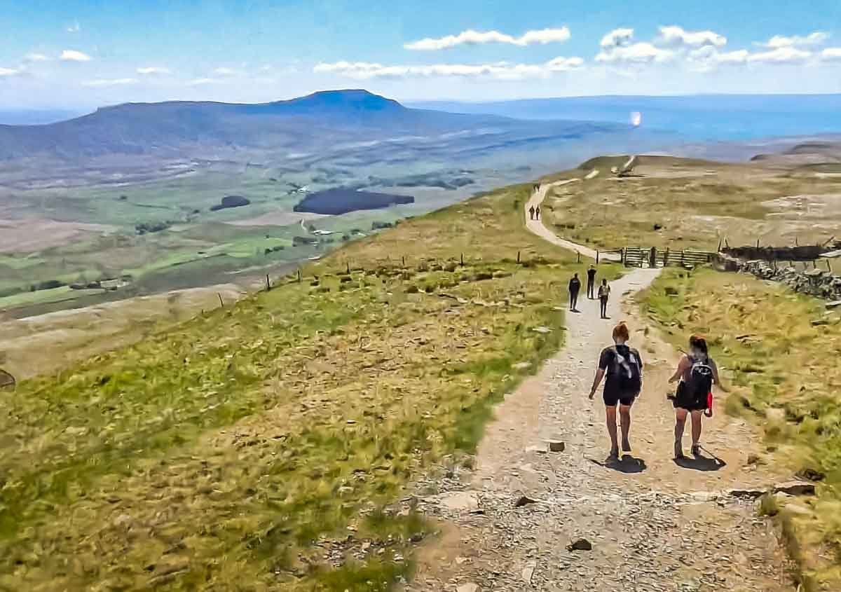
5. The Route, Step-by-Step: A BaldHiker’s Journey
The traditional Yorkshire 3 Peaks route begins in Horton-in-Ribblesdale and tackles the peaks in an anti-clockwise direction: Pen-y-ghent first, followed by Whernside, and finally Ingleborough. This narrative guide breaks the 24.5-mile journey into four distinct legs, detailing not just the path but the experience of walking it.

Leg 1: Horton-in-Ribblesdale to Pen-y-ghent Summit (Approx. 3 miles)
The Route: From the main car park in Horton (Grid Ref: SD 807 725), the walk begins by heading south through the village, passing St. Oswald’s Church and the Golden Lion pub. A left turn onto a minor road leads towards Brackenbottom. From here, a clear footpath strikes left, beginning the steady climb up through fields towards the imposing southern face of Pen-y-ghent. The path steepens considerably for the final section, becoming a rocky scramble that requires the use of hands for balance before emerging onto the summit plateau and the trig point.
The Experience: This first leg is defined by anticipation. The gentle start through the village quickly gives way to the reality of the challenge as the mountain looms ahead. The steep climb is a shock to the system, a stern but fair test that immediately assesses your fitness and resolve. Reaching the first summit is a moment of exhilaration, offering the first panoramic views of the day and a clear sight of the next two peaks laid out across the landscape.
Pro Tip: It is easy to set off too quickly on the initial flat section. Conserve energy and maintain a steady, sustainable pace from the very beginning. The rocky scramble near the summit can be very slippery in wet conditions; focus on secure handholds and footholds and do not rush.

Leg 2: Pen-y-ghent to Whernside Summit (via Ribblehead) (Approx. 11 miles)
The Route: From the summit of Pen-y-ghent, cross the wall and take the clear path heading north, which descends in a series of zig-zags. The path passes the gash of Hunt Pot and continues over Whitber Hill before eventually reaching the B6479 road. A right turn follows this road (with care, as it can be busy) to the iconic Ribblehead Viaduct. Pass beneath the viaduct arches and pick up the obvious path that runs alongside the Settle-Carlisle railway for about 1.5 miles. The path then crosses the railway and begins the long, gradual climb up the flank of Whernside to its summit ridge.
The Experience: This is the longest and most psychologically demanding leg of the challenge. It is a long, grinding walk that tests mental fortitude as much as physical endurance. The landscape is vast and open, a mix of moorland and green valleys. The highlight is undoubtedly the approach to Ribblehead; the scale of the viaduct against the backdrop of the fells is one of the great sights in the British countryside and serves as a powerful milestone. The climb up Whernside feels relentless but rewards with ever-expanding views.
Pro Tip: This long section is the ideal time to refuel and hydrate consistently. Find a steady, rhythmic pace and stick to it. While much of the path has been improved to mitigate the historically boggy ground, it is still a long slog. Use the viaduct as a mental checkpoint for a short break to eat a snack and prepare for the second major climb.

Leg 3: Whernside to Ingleborough Summit (via Chapel le Dale) (Approx. 5.5 miles)
The Route: The descent from Whernside’s summit follows the ridge southwards before turning left onto a very steep, stone-pitched path that drops sharply down towards Bruntscar Farm and the valley below. After reaching the B6255 road, turn left, pass the Old Hill Inn, and then take a grassy path on the right. This path crosses several fields and an area of spectacular limestone pavement before reaching the base of Ingleborough. From here, the final major ascent begins—a very steep, direct climb up a stone-pitched path to the summit plateau.
The Experience: The descent from Whernside is notoriously hard on tired knees. The steepness requires concentration and careful foot placement. The walk across the limestone pavement offers a brief respite before the final, brutal challenge. The climb up Ingleborough is a pure test of will. Legs are screaming, and energy reserves are low, but the sight of the summit shelter getting closer provides a huge mental boost. Reaching the top of the third and final peak is a moment of profound achievement and relief.
Pro Tip: Walking poles are invaluable on the steep descent from Whernside; they help to brace against the impact and save your knee joints. The final climb to Ingleborough is a grind. Break it into small, manageable sections. Count your steps, focus on your breathing, and look back at Whernside to remind yourself of how far you have come.

Leg 4: Ingleborough Summit to Horton-in-Ribblesdale (Approx. 5 miles)
The Route: Navigating off Ingleborough’s broad summit plateau requires care, especially in mist. From the trig point, a bearing of roughly 070 degrees is needed until the ground steepens, then a bearing of 100 degrees will lead to the main descent path. The path heads east, dropping gradually back towards the valley. It passes through the dramatic limestone gorge of Sulber Nick and crosses a few final fields before reaching Horton-in-Ribblesdale railway station, with the car park and the finish line just a short distance further on.
The Experience: This final leg is a mixture of elation and exhaustion. The descent seems to go on forever, and the hard, rocky path can be punishing on weary feet. The unique limestone scenery is beautiful but demands concentration. The first sight of the houses and lights of Horton is a welcome and powerful motivator, pulling you towards the finish. Crossing the river and walking back into the car park marks the end of an epic day.
Pro Tip: Do not lose concentration on this final descent. This is where the majority of tired slips and trips occur. The limestone pavement can be treacherous when wet. Keep a steady pace and focus on your footing all the way back to the village.
A GPX file of the standard route is an invaluable tool for use with a GPS device or smartphone app, but it should always be used as a supplement to a physical map and compass.
Here is a downloadable GPX file for the Yorkshire Three Peaks Route

6. Beyond the Finish Line: Celebration, Recovery, and Responsibility
Completing the Yorkshire 3 Peaks Challenge is a significant achievement. The journey, however, does not end the moment you stop walking. The experience encompasses the celebration, the recovery, and, crucially, the responsibility that comes with visiting this special landscape.
A Well-Earned Reward: Local Pubs and Hospitality
For many, the first stop after the finish line is one of the area’s welcoming, walker-friendly pubs. A celebratory pint and a hearty meal are a time-honoured tradition.
In Horton-in-Ribblesdale, The Golden Lion Hotel and The Crown Hotel are the main hubs, offering real ales and home-cooked food in an atmosphere buzzing with fellow challengers sharing stories of their day.
At Ribblehead, The Station Inn is a legendary establishment, perfectly positioned with stunning views of the viaduct and Whernside, making it an ideal spot for those starting or finishing their walk there.
In Chapel le Dale, the Old Hill Inn is a historic pub that sits directly on the route between Whernside and Ingleborough, renowned for its excellent food and warm welcome.
Tread Lightly: The Challenger’s Code of Conduct
The immense popularity of the Yorkshire 3 Peaks has placed the environment and the local community under significant pressure. A truly successful challenge is one that leaves no negative trace. Adhering to a code of conduct is not just good practice; it is a fundamental part of respecting the landscape and its inhabitants.
Environmental Responsibility: The path network in the Three Peaks area was once the most severely eroded in the UK. The Three Peaks Project, established in 2009 by the Yorkshire Dales National Park Authority, works tirelessly to maintain and repair the paths, funded in part by donations. Walkers can support this vital work by:
- Sticking to the Path: Deviating from the marked path, especially across boggy areas, widens the erosion scar and damages fragile peatland habitats.
- Leaving No Trace: All litter, including food scraps like banana peels and apple cores, must be carried out. There are no bins on the fells.
- Using Toilets: Use the public toilets in the Horton car park before setting off. If caught short on the trail, move well away from paths and water sources and bury human waste properly.
Community Responsibility: The village of Horton-in-Ribblesdale bears the brunt of the challenge’s popularity. Residents are often disturbed by noise and inconsiderate behaviour. To be a responsible visitor:
- Be Quiet: Many walkers start before dawn. Be respectful of residents by keeping noise to an absolute minimum when moving through the village in the early morning.
- Park Considerately: As detailed earlier, use designated car parks or official overflow fields. Do not block driveways, gates, or roads.
- Support Local Businesses: Buying a coffee, a meal, or staying in local accommodation helps to ensure that the community benefits from the visitors it hosts.
Your Achievement: Certificates and Reflection
While the Pen-y-ghent Café’s traditional clocking-in service has closed, the sense of achievement remains. The Yorkshire Dales National Park Authority offers downloadable certificates on its website for those who complete the full challenge, or even just one of the individual peaks, providing a tangible memento of the day.
7. Yorkshire 3 Peaks Challenge: Your Questions Answered (FAQ)
This section provides quick answers to some of the most frequently asked questions about the challenge.
Conclusion: Carry the Fells With You
To cross the finish line in Horton-in-Ribblesdale is to complete a circle not just on a map, but within yourself.
The physical exhaustion is temporary, but the rewards of the journey endure. The real trophy is not a time on a watch or a certificate on the wall, but the quiet confidence that comes from meeting a formidable challenge head-on.
It is the memory of the sun breaking through the clouds over Ingleborough, the shared encouragement with a fellow walker on the long slog to Whernside, and the deep satisfaction of putting one foot in front of the other when every muscle protests.
The Yorkshire 3 Peaks Challenge is more than a walk; it is an experience that connects you to the raw beauty of the British landscape and to the deep well of resilience within.
It is a reminder of what can be achieved with preparation, determination, and a willingness to be present in the moment. Carry the feeling of the fells with you, and let it be the foundation for your next mindful adventure, wherever the path may lead.


