
Driving west on Nebraska’s Highway 88 near the town of Bridgeport, the world is overwhelmingly horizontal. The vast, rolling prairies stretch to every horizon, a sea of grass under an immense sky.
For hours, this is the landscape—beautiful, yes, but also monotonous. Then, something changes. Two shapes emerge from the plains, rising abruptly as if placed there by a giant’s hand.
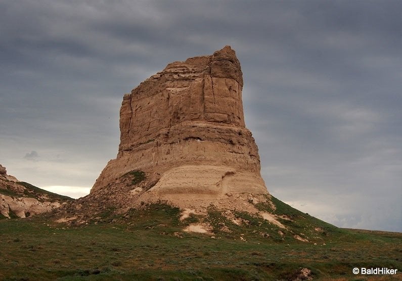
At first, they are smudges on the horizon, but as you draw closer, their scale becomes apparent. These are Courthouse and Jail Rocks, and their sudden, dramatic verticality is a profound interruption of the prairie’s endless expanse.
Having seen them with my own eyes, I sensed the powerful effect they must have had on the 19th-century emigrants.

For travellers on the Oregon Trail, these were not just interesting formations; they were a monumental event.
After weeks, sometimes months, of traversing the seemingly infinite flatness of the Great Plains, Courthouse and Jail Rocks were the very first significant rock formations they encountered.
This moment marked a critical psychological turning point. The familiar, farm-like terrain was ending, and the rugged, unknown West was beginning.
The pioneers, many of whom had never seen anything resembling a mountain, were so struck by these monoliths that they weighed heavily on their memories.
They were the “vanguards of unforgettable scenic wonders,” the first promise of the even more dramatic landscapes that lay ahead, like Chimney Rock and Scotts Bluff.
This article is a comprehensive guide for the modern explorer wishing to follow in those historic footsteps. It covers everything a traveller needs to know, from the practical details of planning a visit to the deep layers of human history, Native American heritage, and geological time that make Courthouse and Jail Rocks a cornerstone of the American West narrative.
The Modern Pioneer’s Guide: Planning Your Visit to Courthouse and Jail Rocks
This section provides all the essential, practical information needed to plan a trip. The site’s raw, undeveloped nature is one of its most compelling features, offering an experience closer to what the pioneers would have seen than more developed historical sites.
This means visitors can enjoy an unobstructed view, free from modern infrastructure, which imparts a powerful sense of solitude and history. However, this authenticity also means being prepared, as there are no facilities on site.
Location & Directions
- Primary Location: The rocks are situated approximately 5 miles south of Bridgeport, Nebraska, and are clearly visible from Nebraska Highway 88.
- GPS Coordinates: For precise navigation, use the coordinates 41°35′49″N 103°06′57″W.
- Accessing the Site: Look for a tombstone-shaped marker for Seybolt Park. This marks the turn-off from Highway 88 onto an unpaved gravel road (designated as Rd 81/Rd 84). The access road runs for just under one mile before ending at a parking area. It is generally well-maintained and suitable for most passenger vehicles in dry weather conditions.
Know Before You Go: The Essentials
- Operating Hours: The site is open to the public year-round, during daylight hours.
- Cost: Access is completely free. There is no admission fee or parking charge.
- Facilities: It is critical for visitors to understand that the site is preserved in its natural state. There are no tourist facilities on site. This includes no restrooms, no drinking water, no visitor center, and no staff presence. The nearest services are available in Bridgeport.
- What to Pack: Given the lack of amenities and exposure to the elements, visitors should bring their own water, sunscreen, a hat for sun protection, and insect repellent. Sturdy walking shoes are recommended for exploring the trail.

Exploring the Site
- Parking & Information: A small, unpaved parking area is located at the end of the access road. Here, visitors will find a historical marker that provides a concise overview of the rocks’ geology and significance to the westward trails.
- The Hiking Trail: A short, informal trail leads from the parking area toward the base of Courthouse Rock, allowing for a closer look at the massive formation.
Safety Advisory: Hiking and Climbing
- Hiking Caution: While the trail to the base is a simple walk, visitors should be aware of the natural environment. The area is home to prairie rattlesnakes, so it is wise to be mindful of where one steps, especially in taller grass or near rock crevices.
- Climbing Courthouse Rock: The trail that once allowed access to the summit of Courthouse Rock has severely eroded over time and is no longer a safe or simple hike. Attempting to reach the top now requires Class 4 scrambling skills, a high level of physical fitness, and experience navigating unstable, crumbly rock faces. The rock itself is composed of soft Brule clay and sandstone, making it prone to further breakage. This ascent should only be attempted by experienced and properly equipped climbers.
- Climbing Jail Rock: An ascent of Jail Rock is even more perilous and is considered a technical climb suitable only for the most skilled and experienced rock climbers in the country. For the vast majority of visitors, the rocks should be appreciated from their base.

Echoes from the Trail: A Journey into History
To stand at the foot of Courthouse Rock is to stand at a crossroads of history. This was not just a landmark on the Oregon Trail; it was a central hub for the great 19th-century migrations.
The Oregon-California Trail, the Mormon Trail, the Pony Express Trail, and the later Sidney-Deadwood Trail all passed nearby, making this ground witness to one of the largest movements of people in American history.
A Castle on the Plains: The Emigrant Experience
After the challenging descent into the North Platte Valley at Ash Hollow, emigrants were greeted by a landscape that would define the next stage of their journey, beginning with Courthouse Rock.
The sight was so astonishing after the featureless plains that many wagon trains would detour up to five miles off the main trail just to get a closer look and marvel at its scale.
The diaries and journals of these travelers are filled with descriptions of awe. An 1845 traveler penned one of the most evocative accounts, stating the rock resembled “the ruins of an old castle [which] rises abruptly from the plain… It is difficult to look upon it and not believe that art had something to do with its construction. The voyagers have called it the Courthouse; but it looks infinitely more like the Capitol”.
This comparison to grand civic architecture was common, providing a dose of familiarity and a tangible milestone for people far from the homes they had left behind. Artist Alfred J. Miller simply called it a “curious formation of Earth,” while the famed British explorer Sir Richard Burton was more skeptical, writing that it “resembled anything more than a court house” and looked more like an “irregular pyramid”.

The Story in a Name
The landmark was first documented by explorer Robert Stuart in 1812, but it would be given many names by the thousands who followed.
Emigrants, letting their imaginations roam, called it “McFarlan’s Castle,” the “Solitary Tower,” “The Church,” and even “Coffins”.
The name “Courthouse” was first recorded in 1837 and, due to its resemblance to the St. Louis courthouse familiar to many Missouri emigrants, it became the most widely adopted name.
Consequently, the smaller, adjacent rock was logically dubbed the “Jail” or “Jail House”. Interestingly, pioneer accounts rarely mention Jail Rock specifically, focusing their wonder almost exclusively on its larger companion.
The Fading Signatures
It was a common practice for pioneers to leave their mark on the trail’s great landmarks, a way of etching their existence into the history of this monumental journey.
Many carved their names into the soft, accessible base of Courthouse Rock. However, the very geology that made this possible also ensured its impermanence.
The soft Brule clay of the rock’s lower sections is highly susceptible to erosion. Over the last century and a half, the relentless forces of wind and water have completely worn away these personal inscriptions, erasing every name.
This natural process serves as a poignant reminder of the nature of historical memory. The individual acts of leaving a mark—an attempt to say “I was here”—were as fleeting as a single lifetime.
What endures is not the personal signature but the collective story of the migration and the silent, timeless landmark that witnessed it all.

A Land Before Time: The Geological Story of the Rocks
The story of Courthouse and Jail Rocks began long before any human laid eyes on them, written in layers of sediment over millions of years. Understanding their geology transforms them from simple landmarks into monuments of deep time.
Forged by Water and Time
Tens of millions of years ago, the entire North Platte Valley was a vast, high plain, filled with alluvial deposits of sand, mud, and volcanic ash washed down from mountains to the west.
Over eons, the ancient North Platte River began to carve a path through this plateau. The river, along with the persistent forces of wind and rain, slowly stripped away the softer layers of sediment.
The reason Courthouse and Jail Rocks survived this immense erosional process lies in their composition. They are capped by a more resistant layer of Gering sandstone mixed with hard limestone.
This durable caprock acted like a shield, protecting the softer layers of Brule clay and volcanic ash beneath it while the surrounding, unprotected land was washed away.
What remains today are these isolated erosional remnants, standing as solitary witnesses to a landscape that no longer exists.
Reading the Layers of Deep Time
The distinct layers visible in the rock faces are a timeline of ancient environments. The sediments at the very foot of Courthouse Rock were laid down approximately 35 million years ago during the Oligocene Epoch.
The layers are composed primarily of Brule clay, Gering sandstone, and volcanic ash that drifted eastward from ancient eruptions.
The Rocks by the Numbers
To appreciate their presence on the plains, consider their scale:
- Height: The formations rise approximately 400 feet (about 120 meters) above the floor of the North Platte Valley.
- Elevation: The base of the rocks sits at an elevation of roughly 4,050 feet (1,230 meters) above sea level.
The Original Inhabitants: Native American Heritage in the North Platte Valley
Long before the Oregon Trail carved its path across the continent, the lands around Courthouse and Jail Rocks were a vibrant and ancient homeland.
To tell the story of the trail without acknowledging the thousands of years of human history that preceded it is to tell an incomplete story. Archaeological evidence shows that people have lived in the North Platte Valley for at least 13,000 years, adapting to its fluctuating climates and ecosystems.
The People of the Plains
During the era of westward migration, this region was the territory of several Native American tribes.
The Pawnee had the longest tenure in the area, with established villages along Nebraska’s waterways, while the powerful Teton Sioux (Lakota), along with the Arapaho and Cheyenne, had migrated into the region and developed horse-centric cultures dependent on the vast bison herds.
For these peoples, the land was not a wilderness to be crossed, but a home that provided sustenance, spiritual meaning, and cultural identity.
The “Great Medicine Road” and a World Disrupted
Initial encounters between Native peoples and the first white fur traders were often peaceful and centered on trade.
However, the establishment of the emigrant trails, which some tribes called the “Great Medicine Road,” marked a profound and devastating disruption.
The arrival of hundreds of thousands of emigrants with their countless wagons and livestock had a catastrophic ecological impact. The wagon trains stripped the delicate prairie ecosystem of grass and timber and, most critically, drove away the bison herds that were the cornerstone of the Plains tribes’ economy, diet, and culture.
This depletion of resources was the primary driver of the growing resentment and conflict. While many early emigrant diaries speak of peaceful encounters, the increasing pressure on the land inevitably led to violence.
Not far from this region, near Ash Hollow, the U.S. Army attacked a Brule Sioux village in 1855 in what became known as the Harney Massacre (or the Battle of Blue Water Creek).
This event was one of the first major military engagements between the U.S. and the Sioux, a tragic precursor to the decades of conflict that would follow the disruption brought by the westward trails.
The Journey Continues: Exploring More Oregon Trail Landmarks
A visit to Courthouse and Jail Rocks is just the beginning of an incredible journey through a corridor of American history. The site is the first of three major Oregon Trail landmarks in western Nebraska, each with its own unique story and character. Planning to visit all three provides a richer, more complete understanding of the pioneer experience.
The Nebraska Landmark Trio
- Chimney Rock National Historic Site: Located about 20 miles west of Courthouse Rock, Chimney Rock is arguably the most famous and iconic landmark on the entire Oregon Trail. Its unique, slender spire was mentioned in more pioneer diaries than any other feature. Today, the site is managed by History Nebraska and features an excellent visitor center and museum that delves into the story of the great migration. An admission fee is required to enter the museum.
- Scotts Bluff National Monument: Roughly 23 miles further west from Chimney Rock, the journey culminates at the imposing Scotts Bluff. Towering 800 feet above the river, this massive formation was a major navigational feature and challenge for the wagon trains. Now a National Monument, it offers a visitor center, hiking trails, and a paved road that takes you to the summit for breathtaking panoramic views of the North Platte Valley. There is no entrance fee for the monument.
Pioneer Landmarks at a Glance
For travelers planning a trip through the region, this table provides a quick comparison of the three key landmarks.
| Feature | Courthouse & Jail Rocks | Chimney Rock National Historic Site | Scotts Bluff National Monument |
| Location | 5 miles S of Bridgeport | ~20 miles W of Courthouse Rock | ~23 miles W of Chimney Rock |
| Height | ~400 ft above valley | ~325 ft above valley | ~800 ft above valley |
| Geology | Brule clay, Gering sandstone | Brule clay, volcanic ash | Sandstone, siltstone, limestone |
| Pioneer Significance | First major rock landmark | Most mentioned in diaries | Major navigational challenge |
| Visitor Facilities | None (Parking only) | Visitor Center, Museum | Visitor Center, Summit Road |
| Cost | Free | Admission Fee | Free |
Exploring Bridgeport
The nearby town of Bridgeport serves as the perfect base for exploring the region’s historical sites. Visitors are encouraged to support the local community by exploring its attractions.
- Pioneer Trails Museum: Located in Bridgeport, this museum offers a deeper dive into the area’s rich history, with artifacts from the trail era and early settler life. It is an essential stop to add context to your visit to the rocks.
- Bridgeport State Recreation Area: For those looking to camp or enjoy the outdoors, this area offers fishing, boating, and swimming in a series of sandpit lakes just west of town.
- Local Amenities: Bridgeport offers a range of services for travelers, including restaurants, motels, and gas stations.


