
There is a unique atmosphere in the Upper Derwent Valley that you don’t quite find anywhere else in the Peak District.
It’s not just the grandeur of the reservoirs or the dark, pine-clad slopes that remind you of Canada or Scandinavia; it’s the sense that history is watching you from just beneath the surface.
I’ve walked this circular route many times, and every visit reveals a new layer of its story.

Whether you are here for the thunderous roar of the dam overflowing in winter, the ghostly outlines of drowned villages in a summer drought, or simply to tread in the slipstream of the Dambusters, this walk delivers on every level.
But, before we lace up our boots and head into the past, here are the essentials you need to know—because getting caught out with no phone signal and no parking coins is a modern history lesson you don’t want to learn the hard way!

Walk at a Glance: The Essentials
|
Feature |
Details |
|---|---|
|
Start/Finish |
Fairholmes Visitor Centre (Upper Derwent Valley) |
|
Postcode |
S33 0AQ (Note: Sat-nav can be patchy) |
|
Distance |
Full Circular: ~10 miles (16km) |
|
Short Option |
Dam Wall & Back: ~1-2 miles (Accessible) |
|
Difficulty |
Moderate (Full loop) / Easy (West side only) |
|
Terrain |
Tarmac road (West side) / Rougher tracks (East side) |
|
Parking Cost |
~£6.00 All Day (Bring coins—card machines often fail!) |
|
Best For |
History buffs, Dambuster fans, and family strolls |
The Fortress of Water: Derwent Dam
Starting from the Fairholmes Visitor Centre, the first thing that strikes you is the Derwent Dam itself. It doesn’t look like a piece of industrial utility; it looks like a fortress.
Completed in 1916, this massive masonry wall stands 114 feet high, framed by two gothic stone towers that feel more like castle turrets than engineering access points.
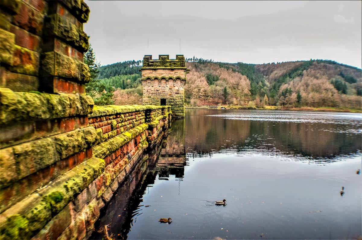
The “Overtopping” Spectacle
If you visit after heavy winter rains, you’re in for a treat. Unlike the famous “plugholes” at Ladybower (which are further south), Derwent Dam is designed to cascade.

The water pours directly over the crest of the wall, creating a deafening, man-made curtain of water. It’s a photographer’s dream, but be prepared for the spray!
Echoes of the Dambusters
As you walk the path along the reservoir, it’s impossible not to look skyward. This valley was the classroom for one of World War II’s most audacious missions.
In 1943, the pilots of 617 Squadron flew their Lancaster bombers low through this narrow valley, practicing for the raids on the Ruhr dams in Germany. The topography here was a near-perfect match for the target sites.

Keep an eye out for the memorial stone at the West Tower dedicated to the squadron. And if you’re lucky—or perhaps unlucky, depending on your nerves—you might hear the roar of a modern RAF Hercules or Chinook on a training run.
Local legend even speaks of “Ghost Planes”—silent Lancasters seen gliding through the mist, a phantom echo of the past.

Birchinlee: The City of Tin
Walking up the west side of the reservoir, you’ll spot markers for the “Tin Town Trail.” It’s hard to imagine now, amidst the quiet trees, but between 1901 and 1916, this spot was a bustling “Wild West” style boomtown called Birchinlee.
This wasn’t a chaotic camp; it was a model village built to house the massive army of navvies building the dams.
It had everything: a hospital, a school for the workers’ children, a police station, and even a department store run by the Gregory brothers from Tideswell.
There was a recreation hall for dances and a pub for the thirsty workers. Today, only the stone foundations remain hiding in the bracken, but if you pause, you can almost hear the fiddle music from the Saturday night dances.

Solitude at Slippery Stones
If you commit to the full 10-mile loop, you’ll reach the northern tip of the valley: Slippery Stones. This is my favourite spot. The crowds from the visitor centre rarely make it this far, and the landscape feels wilder, opening up towards the bleak moors.
Here, you’ll find an old stone packhorse bridge crossing the River Derwent. It looks like it’s been there for centuries, and it has—just not here.
This 17th-century bridge was originally located further south near Derwent Hall. When the Ladybower reservoir was built in the 1940s, the bridge was painstakingly dismantled, stone by stone, numbered, stored, and then rebuilt here in 1959 to save it from the rising waters.
It’s a beautiful little bridge to nowhere, saved by history lovers.

The Mystery of the Drowned Villages
The return leg of the walk takes you down the east side (which is rougher and less pram-friendly, by the way!).
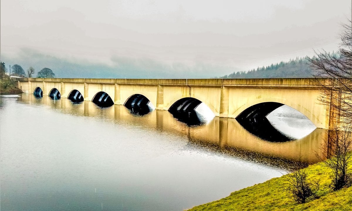
As you look out over the water, you are looking at a grave. Beneath the surface of the Ladybower Reservoir (just south of Derwent Dam) lie the ruins of two villages: Derwent and Ashopton.

Ashopton’s Final Hymn
Ashopton was a vibrant community with a coaching inn and a Methodist Chapel. The story of its end is heartbreaking. On 25th September 1939, the congregation held their final service at the chapel before the waters came.
They sang “The Day’s Dying in the West” as their final hymn—a poignant farewell to their home. Today, Ashopton is buried deep under the silt near the viaduct.
Derwent Village & The Great Drought
Derwent village, however, refuses to stay hidden. It contained the magnificent Derwent Hall, a 17th-century manor with oak panelling dating back to 1672.16 While the hall was demolished in 1944, its foundations remain.

During extreme droughts—like the scorching summers of 1976, 1995, and recently 2018—the water recedes enough to reveal the “Ghost Village.” You can walk the old streets, see the cottage outlines, and trace the floorplan of the Hall.

Note: You might hear stories about the church spire sticking out of the water. That was true once, but the spire was dynamited in 1947 because people kept trying to swim out to it!

Practical Logistics: Don’t Get Caught Out!
While the romance of the place is undeniable, the logistics can be tricky. Here are my top tips for a stress-free visit:
- Bring Real Coins: The parking machines at Fairholmes often don’t play nice with cards, and the mobile signal is virtually non-existent, so don’t rely on parking apps. Bring £6 in coins to be safe.
- Weekend Road Closures: If you’re planning a lazy drive up the valley on a Saturday or Sunday, think again. The road beyond Fairholmes (towards Slippery Stones) is closed to traffic on weekends and Bank Holidays to protect the peace. You’ll have to walk, cycle, or take the shuttle bus.
- Choose Your Side: If you have a pushchair or wheelchair, stick to the West Side road. It’s tarmac and flat. The East Side track through Hancock Wood is rougher, muddy, and has exposed roots.
- No Signal: Download your maps (or this guide!) before you leave home. Once you pass the viaduct, you are off the grid.

Frequently Asked Questions
Other great walks in the area:
Alport Castles Walk – Derbyshire Peak District
Win Hill Pike – A snow covered pimple


Looks absolutely stunning. Can u tell me how far this circular walk is and where about you started from please. Possible postcode maybe x
Hello Trudy,
Thank you, it’s a beautiful area indeed.
For parking, there’s often parking space available for free in dedicated spaces beside Ladybower reservoir. Best parking but paid for is at Fairholmes visitor centre post code Hope Valley S33 0AQ
The circular walk from Fairholmes visitor centre around past the dam and over Ashopton viaduct, and along the other side to a full circle is roughly 6 miles (9km.) or taken the other way around.
I hope you manage to visit and enjoy the area.
kind regards,
Janine
Beautiful and interesting! Tell me, how did the Derwent Damn drown??
Hello Jane,
It really is a lovely area to explore. Thank you very much, I’m glad you’ve found it interesting.
By drowning, do you mean how the dam overflowsin the photo? This will happen after a good winters rain and snow has filled the Derwent and Howden reservoirs, enough to allow it to, over top, to flow over the top of the dam.
This year has been a hot year, and the reservoirs are all very low indeed and so are quite low for the time of year. I hope I’ve answered your question. Thanks again, Janine
Hi Charlie,
I’m sure you would enjoy the area, it’s well worth stopping to explore. Thanks for the lovely coment on the photos too.
All the best,
Janine
We often drive along Snake Pass when visiting family, so will have to stop and do this walk! Looks lovely. Great photos!